Gregorio Pascual Santamaría
Head, Natural Risks Area
General Directorate for Civil Protection and Emergencies
(Dirección General de Protección Civil y Emergencias)
Introduction
In risk assessment, as in any human activity, if we expect to obtain acceptable results, it is imperative to handle the best data possible. With the degradation of any process, if we introduce approximate or unreliable data into our calculations, we will obtain results of even poorer quality than that of the data introduced. For this reason, having the origin of the data we handle under control is as important as the calculation processes we use.
In the risk assessments to be used as the basis for the establishment of Risk Reduction policies, it is essential to have our data sources well controlled and to be aware of their limitations and the possibilities of manipulation.
Moreover, to be able to automatically reproduce the calculations made, whenever any change occurs in them, it is essential to have obtained them in the first place from reliable institutions that will guarantee both the quality of the data as well as their traceability.
With the development of the new technologies, there are a number of solutions that facilitate the work of the departments responsible for risk assessment, enabling them to provide advisory services with greater guarantees to the persons responsible for decision-making.
We will make a brief review of two elements that contain solutions which could significantly assist risk assessment technicians:
The Spanish Spatial Data Infrastructures (Infraestructuras de Datos Espaciales Españoles, SSDIs) developed in accordance with the INSPIRE regulations.
The Loss and Damage Databases promoted by the Sendaistrategy for disaster reduction.
The SDIs: Spatial Data Infrastructures are an extraordinary tool for the analysis of any process that has to do with the territory. Given that the elements managed in risk assessments are related to the territory, it is worthwhile to examine, even briefly, the current status of the development of this technology and its application in the area of Civil Protection in Spain, in the hope that these reflections will be of use to groups interested in this subject.
1.1. Some history
Act 14/2010, of 5 July, on the geographic information infrastructures and services in Spain (Ley sobre las infraestructuras y los servicios de información geográfica en España, LISIGE) transposes into Spanish law the European Directive 2007/2/EC, establishing a spatial information infrastructure in the European Community (INSPIRE), thereby guaranteeing compliance. This Act includes the establishment of information infrastructures and interoperable geographic information services under the responsibility of the Spanish Public Administrations. This legislation establishes the obligation of publishing all map elements that describe risks, vulnerabilities, resiliencies and the like, in accordance with the specifications of the INSPIRE Directive.
As early as 2006, prior to the publication of the Act, the first day-long meeting was organised in the National Civil Protection School (Escuela Nacional de Protección Civil) on the INSPIRE initiative and its application to Civil Protection, with the participation of a large number of entities interested in the subject. The most important conclusions reached at this meeting, held in Madrid in January 2006, were:
1) The Spatial Data Infrastructures (SDIs), as technologies enabling the publication, visualisation and analysis of geographic data at low cost and in an interoperable manner, constitute a new paradigm which is revolutionising the world of Geographic Information (GI) and offers fresh possibilities that need to be explored and taken advantage of…
(…)
4) The basic tasks of Civil Protection consist of seeking to put into play all possible means for avoiding a catastrophe or public disaster and, if any do occur, for minimising the effects on the population and their possessions…
5) The SDI technologies are extremely useful for the tasks of Civil Protection. These technologies solve the problem faced by the General Directorate for Civil Protection and Emergencies in accessing and integrating spatial reference data and a wide range of updated thematic data on the local, regional, national and international levels, thereby enabling interoperability with its emergency response information systems…
(…)
7) In any case, to meet the requirements of information and availability of services necessary for the objectives and tasks of Civil Protection, it will be necessary to ensure:
• the availability in any place, in any conditions and under any circumstances of updated spatial data. • high speed of access and downloading of information. • maximum privileges in the search for, visualisation and downloading of data referring to its scope of responsibility, for subsequent processing in the performance of its duties…
(…)
13) Other organisations are invited to collaborate in the European forums opened as well as in the growth of the SDI portal. Specifically, and in view of the needs of Civil Protection, it is considered advisable to maintain and reinforce collaboration within the framework of the activities of the SSDI WG and, particularly, to participate in the drafting of the INSPIRE Implementing Rules.
1.2. Development of the different situations
An SDI can be defined as a set of resources (servers, applications, data, catalogues of metadata, services, nomenclatures...) which make it possible to search for, visualise, combine and analyse the geographic data available in the Internet and in any location whatsoever.
The task of defining and developing the Spanish Spatial Data Infrastructure (SSDI) has been assigned by the Superior Geographic Council to the Geomatics Commission (Consejo Superior Geográfico a la Comisión de Geomática). This Commission set up a Working Group for the definition and development of the Spanish Spatial Data Infrastructure (SSDI WG) in which the General Directorate for Civil Protection and Emergencies (Dirección General de Protección Civil y Emergencias - hereinafter, DGPCE) participates.
It is therefore evident that the Civil Protection and emergency management sector can obtain considerable advantages by using this technology and working method, becoming integrated into a national infrastructure that will open the doors to any and all available information. Institutions exist that generate, maintain and manage all kinds of specific data valid for preventing or mitigating the risks to which the population, their possessions and the environment can be exposed.
Considering that this information is dispersed and in a multiplicity of formats, institutions, scales, media, and the like, it is indispensable, in attention to the INSPIRE regulations, to establish a system of metadata (data that give information about the characteristics of other data) to facilitate documentation search tasks, allowing interoperability between all available mapping. These functions are of vital importance in the planning, management and recovery phases of emergencies.
The DGPCE prepared a document in October 2006 with the following content:
Analysis of the needs of the General Directorate for Civil Protection and Emergencies, describing the functionalities required for the management of the metadata.
Analysis of the Spanish Metadata Core (Núcleo Español de Metadatos) in which the relevant analysis is made for the purpose of providing responses to the needs identified by the General Directorate for Civil Protection and Emergencies.
Analysis of alternatives, in which the various options are discussed for meeting the needs identified by the General Directorate for Civil Protection and Emergencies.
Proposal for the creation of new elements in the standard metadata profiles, in which the solution adopted, is specified.
Despite the fact that the DGPCE gave the strongest support possible by liaising with Civil Protection technicians in the Autonomous Communities, for a number of reasons, no applicable results were obtained in this initiative, and the Civil Protection technicians who participated in the working group are now awaiting guidelines to be sent both by the DGPCE as well as by the Superior Geographic Council, to try to make progress in this scope.
1.3. Evolution of the organizational aspects
The significant development of the network-based applications, of the capturing of geographic data, as well as of their processing and standardisation, together with the determination of the National Geographic Institute to make all of the data generated by that institution available to society, cost-free and through easy access, has given rise to the spectacular development of the organisations that generate and manage geographic data through SDIs.
To achieve this development, the private companies that have joined INSPIRE have not been oblivious to the process, and they are to be thanked for, as it is a great opportunity for generating business. Besides, in some cases they took advantage of the possibility of obtaining funding from the European Union for their developments. This EU funding are, nevertheless, lacking rigour at the time of assessing results, as the prime focus is always set on generating business over the potential technical benefits achieved. For instance, EU funds mappings with fewer requirements for accuracy and resolution than those already available from some Member’s national Map Services, being, moreover, these maps public and free.
The development of the official SSDI nodes operating on the central or regional government levels in Spain can be consulted on the website: http://www.idee.es/web/guest/inicio(1), with a range of applications and data offered through easy and cost-free access. On the central government level, the servers of the following institutions are of particular interest:
Ministry of Agriculture and Fisheries, Food and Environment.
Ministry of Economy, Industry and Competitiveness.
Ministry of Public Works.
Sociedad Estatal de Correos (Mail Service).
Ministry of Energy, Tourism and the Digital Agenda.
Ministry of Justice.
Ministry of the Treasury and Public Service.
Europarc España.
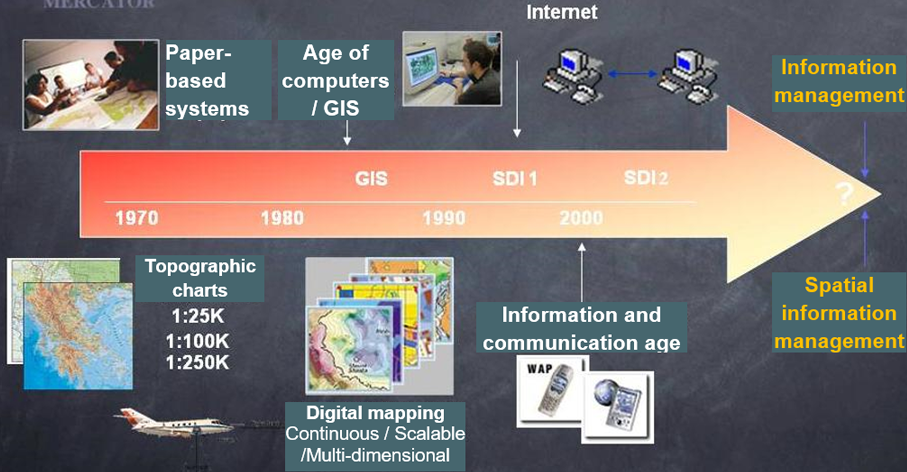
Figure 1. Evolution of mapping systems.
(Miguel A. Bernabé and Miguel A. Manso U. Politécnica Madrid)
The development and implementation of services on a European scale can be consulted on http://inspire.ec.europa.eu/.
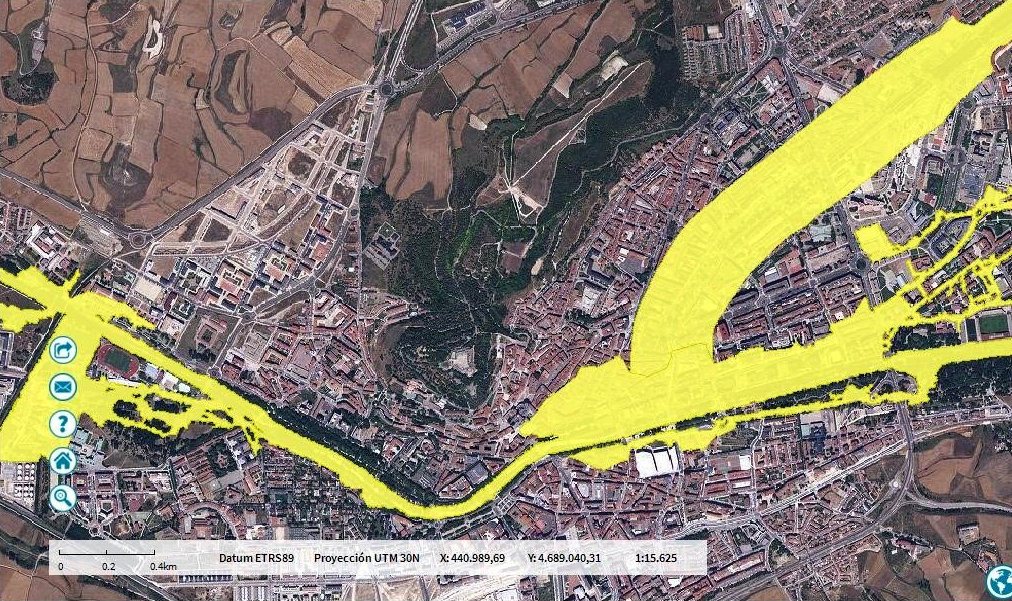
Figure 2. Flooding that can be expected for a return period of 500 years for the city of Burgos. Taken from the National Flood Area Mapping System (Sistema Nacional de Cartografía de Zonas Inundables) maintained by the General Directorate for Water Resources (Dirección General del Agua).
At a regional level, the range of data is spectacular and can be consulted on the aforementioned website.
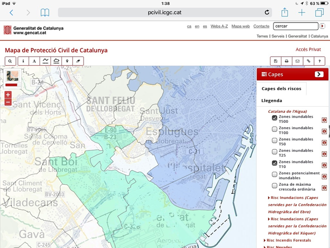
Specific mention must be made of the Civil Protection Map of Catalonia (Fig. 3), offered by the Generalitat (Regional Government) of Catalonia and which, although not offering all of the services that a Civil Protection server could provide, at least visualises and compiles the information needed for the management of the risks to which the territory is exposed. A hierarchical system needs to be developed, capable of considering and providing Civil Protection data in a scaled manner, depending on the institutions comprising the National Civil Protection System in a position to offer the best updating and maintenance services.
The municipal SDIs basically manage the urban development of the towns as well as tax collection and utilities’ maintenance, but evidently are yet another link in the chain of services generating this tool.
In the private sphere, information is being managed which also impacts positively on the increase in the applications managed through the INSPIRE philosophy.
Although its development has been spectacular, the process has not been problem-free. Many European countries refused to provide their data due to copyright problems or commercial interests. In addition, within the European institutions, the policies of the national agencies are not taken into account, and the generation of business takes precedence over the unification of criteria and the standardisation of European cartographies with the data of national cartographies of sufficient quality.
The economic crisis has led to the abandonment of work strands due to a lack of funding. In some cases, the gap opened through this abandonment by trained technicians with the knowledge required for developing the products necessary has come to be filled by technicians who, without sufficient expertise and latching on to the latest trends, try to take advantage of the name of INSPIRE. Evidently, this ends up by blocking the processes which, in principle, were being generated.
Figure 3. Civil Protection map offered by the servers of the Regional Government of Catalonia (http://pcivil.icgc.cat)
2. Loss and damage databases
Since the meeting on Disaster Risk Reduction held in Sendai (Japan) in March 2015, the development of applications and the capturing of data to enable the quickest possible assessment of the damages and costs generated by each emergency have been taking place on a world scale. Later, in Cancun (Mexico), in May 2017, the process was consolidated, and methodologies were proposed for addressing the goals set.
2.1. The Sendai Framework for Disaster Risk Reduction (2015-2030)
The Sendai Framework for Disaster Risk Reduction was approved by the Third UN World Conference on Disaster Risk Reduction, held in Sendai (Japan) in March 2015.
The four priority spheres of action determined at that meeting were:
Understanding disaster risk.
Strengthening disaster risk governance to manage disaster risk.
Investing in disaster reduction for resilience.
Enhancing disaster preparedness for effective response and to “Build Back Better” in recovery, rehabilitation and reconstruction.
To achieve this priority of “understanding disaster risk”, both on the national as well as the local level, it is important, among other aspects, to: assess, record, share and convey to the public, systematically, the losses caused by disaster and understand the economic, social, health, education and environmental impact and the effects on cultural heritage, in the context of the information on vulnerability and the degree of exposure to threats referred to specific events.
The Sendai Framework 2015-2030 has led the development of indicators on loss data through the Open-ended Intergovernmental Expert Working Group on Indicators and Terminology relating to Disaster Risk Reduction (OEIWG). The indicators established will be used in other agreements on disaster losses, including the Paris agreement on climate change and the Sustainable Development Goals (SDGs).
2.2. European Union Disaster Loss and Damage Working Group
In November 2013, the Joint Research Centre (JRC) and the Office of Humanitarian Aid and Civil Protection (ECHO) of the European Union set up an expert working group for the purpose of examining how the recording of the data on the loss and damage caused by disasters takes place in the European Union and of recommending best practices and guidelines.
This working group includes representatives of the Member States, of the private sector, of academic and scientific institutions, international organisations and personnel of the services of the European Commission. The Natural Risks Area of the General Directorate for Civil Protection and Emergencies (DGPCE) has participated, practically from the start, by representing Spain and contributing its experience obtained in the preparation of the National Catalogue of Historic Floods (Catálogo Nacional de Inundaciones Históricas).
Based on the results obtained by this working group, the JRC has published the following documents:
Recording Disaster Losses: recommendations for a European approach (2013).
Current Status and Best Practices for Disaster Loss Data Recording in EU Member States: A comprehensive overview of current practice in the EU Member States (2014).
Guidance for Recording and Sharing Disaster Damage and Loss Data: towards the development of operational indicators to translate the Sendai Framework into action (2015-2030).
Figure 4. JRC publications on the development of disaster damage databases.
These documents reflect the commitments of the expert working group for addressing the challenges posed by the new EU Civil Protection legislation and the Sendai Framework for Disaster Risk Reduction.
In this scope, in Spain, work has been in progress for some time in an effort to obtain relational databases that provide information on the damage caused by emergencies. Two examples are the National Catalogue of Historic Floods and the Earthquake Damage Database:
The first of these programmes is set in the framework of the European Floods Directive, which has signified an enormous step forward in the standardisation of programmes and applications for flood risk assessment in Europe.
2.3. EU Floods Directive
Directive 2007/60/EC, on the assessment and management of flood risks, transposed into Spanish legislation by Royal Decree 903/2010, of 9 July, requires the Member States, in its Chapter II, to perform a preliminary assessment of the flood risk (hereinafter, PFRA) for the entire territorial area of each river basin district. The Directive specifies that the areas in which a significant potential risk of flooding exists must be identified. For each of the areas identified in accordance with the Directive, a risk management plan must be drawn up based on flood hazard maps and flood risk maps.
A multidisciplinary working group sourced from different organisations, both public (Spanish General Directorates for Civil Protection, for Water Resources, for Coasts, plus the Public Works Experimentation Centre and the Spanish Geological Survey) as well as private (consultancy firms specialised in hydraulic subjects) designed a methodology for the development both of the PFRAs, as well as of the maps (hazard and risk) and of the management plans.
This methodology defines a number of criteria and methods for establishing a homogeneous diagram that will enable a comparison of the results obtained throughout the territory of Spain, making it possible to adapt the content to the characteristics of each river basin district.
The methodological proposal is supported on the compilation and analysis of the information, readily available in relation to historical references, topography and water network, geomorphology and the identification of alluvial and torrential zones, as well as land use and the changes therein, identification of the existing hydraulic infrastructures, the influence of climate change and the compiling of the studies made on flood risks and/or hazards.
As a result of the analysis of the information compiled, a pre-selection of potential flood risk zones would be identified. These zones will be re-evaluated subsequently in the case of eventual flood defence works or of significant changes in land use.
The methodological proposal assumes that the information on the places where floods occurred in the past is obtained from basic documentary sources, with the National Catalogue of Historic Floods being the essential and homogeneous source of data for the country overall.
The National Catalogue of Historic Floods stems from the meeting of the National Civil Protection Commission held on 20 May 1983, at which a Technical Flood Emergency Committee (Comisión Técnica de Emergencia por Inundaciones, CTEI) was set up, with the participation of the competent bodies of the Central Government Administration, for the purpose of making a study of the corrective measures to be taken in the areas habitually affected by floods and of the risks derived from these situations. The work performed by that Committee, made up by representatives of the Ministries known at that time as the Ministry of Public Works and Town Planning; Ministry of Agriculture, Fisheries and Food; Ministry of Transport, Tourism and Communications and Ministry of Industry and Energy, gave rise to the publication of valuable documentation that included the following studies for each of the ten major river basins in which the Iberian peninsula was divided from a hydrographical point of view:
Analysis of historic floods.
Identification and classification of the zones potentially threatened by flood risks.
Preparation of an array of the most appropriate actions, in each risk zone detected, for correcting or reducing the damage caused by floods.
Despite the length of time transpired since their preparation, to a large extent these studies remain current and of interest. This means that such information must necessarily be consulted by all persons whose activity involves aspects associated with flash floods and other flood events.
The studies of historic floods by the CTEI finalised between 1983 and 1985. However, the uninterrupted succession over the last few years of flood events of an extraordinary nature called for their updating. For this reason, starting from these studies and with a new working methodology, the General Directorate for Civil Protection has been working since 1995 on the National Catalogue of Historic Floods (CNIH), with the objective of systematising and standardising the compiling of data on historic floods throughout the country, as well as for facilitating and ensuring its updating in the face of new flood events.
Since 2007, the General Directorate for Civil Protection and Emergencies has made the historic flood lists of the various river basins available on DVDs, in an effort to provide tools that can be of use both for technicians as well as for the general public in the study of flood risk in Spain.
In November 2016, the DGPCE published the CNIH web application on www.proteccioncivil.es/riesgos/inundaciones/cnih, with a public scope and free access. The volumes published years ago by the Technical Flood Committee (Comisión Técnica de Inundaciones), which served as the basis for the preparation of the catalogue, can be consulted in the same zone of the DGPCE server.
2.4.1. Analysis of the information contained in the CNIH
In 2005, the DGPCE developed an application for the maintenance, operation and analysis of the CNIH, based on the use of databases and Geographical Information Systems (GIS). The system facilitates the introduction of new information on floods (comprising new events as well as the adaptation and updating of the existing data sheets on historic floods), enables the consulting and the analysis of the historical information and serves as a basic support tool in the planning, management and decision-making in flood emergency situations.
The consultation module enables the analysis of the information contained in the CNIH. It makes it possible to perform a range of tasks, such as making pre-determined queries, the generation of fresh queries, the visualisation of all of the information associated with an event, the calculation of statistics, the obtaining of graphics of statistics, thematic maps, reports, as well as export information to Microsoft Office environments.
The tables comprising the database of the Catalogue have been dumped into a web application with the same characteristics and with the capacity to interrelate with the National Flood Zone Mapping System (Sistema Nacional de Cartografía de Zonas Inundables, SNCZI).
In terms of river basins, it must be emphasised that since 1900 the Ebro has been the basin recording the largest number of floods in global terms. Prior to that date, the ranking was led by the Guadalquivir. In the case of the Balearic Islands, as there were no CTEI background data, the information available is even more limited. In any case, for recent dates, a relatively low figure in the number of events of a specific basin does not necessarily mean a low flood frequency, due to the fact that the criteria used by the basin working groups were not always the same and in some cases (the Júcar, Segura, Tagus,…) only included those events in which the damages recorded were very significant.
2.4.2. Estimate of damage costs
As described below and recommended by European Union working groups, new variables have recently been included in the CNIH describing the costs generated by each of the flood events. The intention is to gradually include more of the institutions that process the costs of emergencies, which in principle will be centred on the:
DGPCE: to coordinate, prepare and contribute data on subsidies granted;
Consorcio de Compensación de Seguros: to contribute data on amounts of compensation granted for damages to insured values;
General Directorate for Local Cooperation (Dirección General de Cooperación Local): to contribute data on the subsidies granted to local entities for natural disaster applications;
AURA; ENESA: to contribute data on aid granted for damage to agricultural and livestock productions;
Ministry of Development: to contribute information on the emergency works performed on account of damages caused by certain catastrophes;
Other institutions.
At the present time, the compensation database includes:
The case files of the Consorcio de Compensación de Seguros (CCS) referring to the compensation paid for the insured damages caused by natural phenomena since 1983.
The aid or subsidies granted by the General Directorate for Civil Protection and Emergencies (DGPCE) in view of the needs derived from emergency or natural disaster situations since 1996.
This Plan describes the need for addressing the indispensable weather risk warning network, considering that in Spain the most significant damage, both in material losses as well as in personal injury, arises from flash floods, caused by convective storm developments very difficult to predict, particularly with the limited number of weather radars in use.
In this plan, in articles 3.2 et seq. as well as in Annex 1, the need is discussed and defined for establishing protocols for the proper start-up of warning systems capable of minimising the damages expected in flood situations.
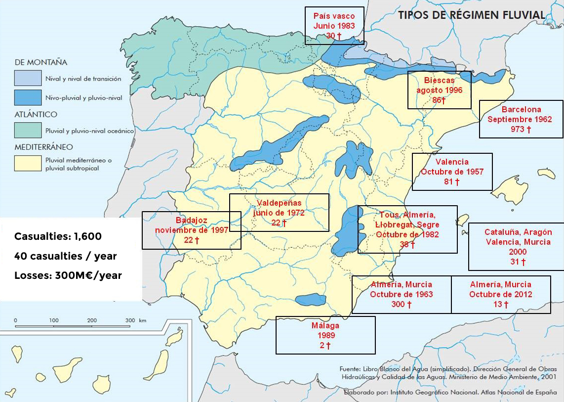
Figure 5. Typologies of the most significant rainfall and flood regimes that have caused deaths in the last 60 years.
4. Catalogue of Earthquake Damage in Spain (Catálogo de Daños por Terremotos en España, CDTE)
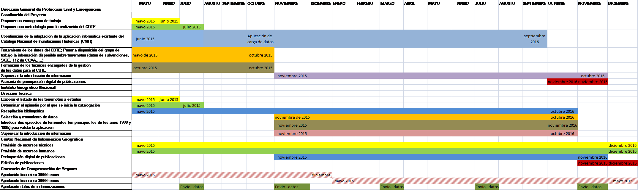
The CDTE is a project which has been in progress since March 2015, as a result of the cooperation agreement signed between the Consorcio de Compensación de Seguros, the General Directorate for Civil Protection and Emergencies, the General Directorate of the National Geographic Institute (Dirección General del Instituto Geográfico Nacional) and the National Centre for Geographic Information (Centro Nacional de Información Geográfica) (see Figure 6). The purpose of the project is to develop an earthquake database to bring together the information dispersed among a number of sources, by applying the guide prepared by the working group on disaster loss and damage in the European Union.
Figure 6. Timetable of the project for preparing the CDTE.
The methodology used for the National Catalogue of Historic Floods (CNIH) has been followed in the development of the CDTE, by adapting it to seismic risk and including aspects in relation to the recording of data on damage and loss in the event of catastrophes, contained in the Guide prepared by the expert working group on disaster loss and damage in the EU, led by the JRC.
At the present time, a complete methodology is available for the characterisation of all of the elements forming the earthquake damage database. Although the database is not complete, the applications necessary are available to enable the cataloguing, recording and subsequent exploitation of the damage data.
Therefore, an intense effort of cataloguing and the completion of forms contained in the application developed lies ahead, in order to comply in full with both the National Civil Protection System Act as well as the Sendai Framework.
Spatial data infrastructures are an essential tool for the management both of the risk as well as of the emergencies and recovery in the scope of Civil Protection.
For the development of an SDI, specialised technical personnel are required for obtaining the data, maintaining the processes and coordinating the relations among the different levels of information. Departments with these duties as their exclusive task need to be created in the coordinating bodies. These professionals must have a profile which includes extensive specific knowledge in the field: databases, geolocation, GIS processing and the like, without necessarily being comparable to computing knowledge in other areas of specialisation.
The creation and management of the Civil Protection SDI is indispensable not only on account of the administrative obligations involved in the INSPIRE Directive, but also for the effective implementation of Act 17/2015, of 9 July, on the National Civil Protection System.
In this same direction, pursuant to article 9 of that Act, the following is mandatory (point e): The National Emergency and Disaster Data Registry (Registro Nacional de Datos sobre Emergencias y Catástrofes), which will include information on the catastrophes that have occurred, the consequences and losses caused, as well as on the resources and procedures used for mitigating them. Objectives which coincide precisely with the Sendai Framework for Disaster Reduction.
For this purpose, the technicians responsible for maintenance must necessarily be provided with a sufficient budget, human resources and computer tools to enable them to attain these objectives.
The knowledge obtained from the emergencies of the past is the only road open for minimising the effects of future emergencies.
In Spain, in terms of the capturing of damage data, systems have been maintained on the basis of the recommendations of international bodies. Nevertheless, it appears of interest to develop procedures that would adapt to local conditions, to avoid a situation where the fact of following the indications of international groups in a literal sense could paralyse the developments achieved up to now.
The warning systems in the face of rapid convective storm developments must necessarily be improved, to be able to reduce the damage caused by flash floods.