Pablo Ferreiro - Tragsatec Abraham Rambla - Tragsatec Mónica Aparicio - Directorate General for Water, the Ministry for the Ecological Transition and the Demographic Challenge Juan Francisco Arrazola - Directorate General for Water, the Ministry for the Ecological Transition and the Demographic Challenge
1. Introduction
Today’s ecological challenges call for collective and individual changes on different scales which both factor in uncertainty as a resource to work with and aspire to more resilient societies.
In recent years, and driven by serious episodes such as the river flooding in Europe or hurricanes Sandy and Katrina in the United States, cities the world over are working on ambitious comprehensive strategies that fuse together global thinking on resilience with specific local conditions. With multidisciplinary teams joining forces that comprise architects, engineers, landscapers and town planners, along with contributions from the fields of natural and social sciences and the involvement of new stakeholders, this systemic approach concedes that we are vulnerable to future disasters and proactively designs responses from the standpoint of the landscape, cities and ultimately buildings.
In Spain, flooding represents the natural risk that causes the most significant harm in terms of both property and human life. In light of this, adapting buildings can make a substantial contribution to keeping economic loss down and boosting the safety of those inside.
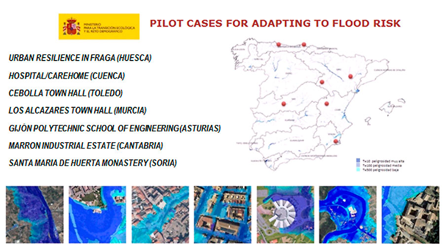
Having publicised its Guides to adapting to flood risk, the Directorate General for Water at the Ministry for the Ecological Transition and the Demographic Challenge is working on a set of pilot cases for adapting to flood risk. These seek to put the concepts in the guides into practice, pick out the general lines of action to apply to buildings according to their purpose, location and constructional attributes, and draw together good practices.
They therefore advance solutions within a multi-scale approach to resilience: long-term territorial transformations which are supplemented by immediate and timely measures at a local level that can withstand events for which no response capability exists in current circumstances.
2. Background
Directive 2007/60/EC of the European Parliament and of the Council of 23 October 2007 on the assessment and management of flood risks aims to set up a framework to focus on “the reduction of potential adverse consequences of flooding for human health, the environment, cultural heritage and economic activity”. Other EU directives associated with river management, such as the Water Framework Directive and the Habitats Directive, present a broad complementary setting for integrated flood risk management.
In Spain, Royal Decree 903/2010 of 9 July on the assessment and management of flood risks marks the transposition of the Floods Directive to the state legal system. On the other hand, Royal Decree 638/2016 of 9 December amending the Hydraulic Public Domain Regulations and the Hydrological Planning Regulations (among others), identifies those activities that are vulnerable to river surges and imposes certain basic limitations on using flood zones.
The National Flood Zone Mapping System (SNCZI for the Spanish) is a support tool for river area management, risk prevention, territorial planning and administrative transparency. At its core is the flood zone map viewer, which allows the public to access information on floodability.
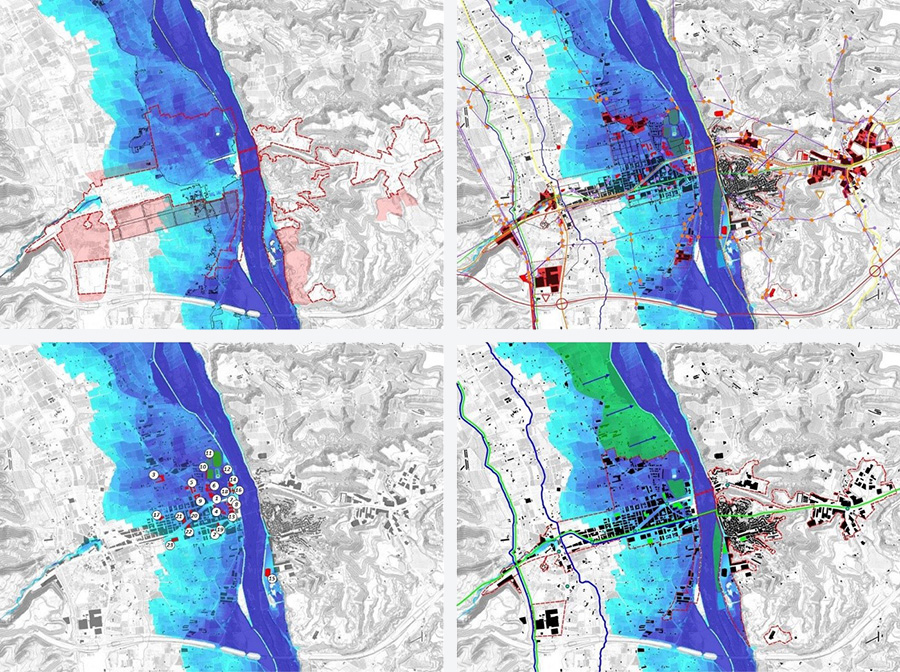
Figure 2. Area around the Gijón Polytechnic School of Engineering (Asturias): hazard map and map of risk to business activities T=500.
Source: SNCZI.
Flood Risk Management Plans (FRMPs) are the reference documents for the government and society in general as regards managing river overflows. Their key content is the programme of measures (including those that concern territorial and urban planning), which includes producing technical guides to reduce the vulnerability of exposed elements.
The Guide to reducing building vulnerability to flooding, which has been drafted within a partnership agreement entered into between the Directorate General for Water and the Consorcio de Compensación de Seguros, provides information on risk management, building design, and both public safety and self protection measures to keep the loss which floods cause to a minimum.
Additionally, under the Environmental Advancement Plan for Climate Change Adaptation in Spain (the PIMA Adapta plan), the Directorate General for Water and TRAGSATEC have produced the following guides, which are being applied to several representative pilot cases:
Figure 3. Guides to flood risk adaptation.
Assessment of the resilience of urban population centres to flood risk: networks, urban systems and other infrastructure, to help pinpoint the direct or indirect harm which a flood can cause to a city or its surrounding area so that action can be taken to enhance resilience.
Sustainable urban drainage systems, to delve more deeply into the causes and consequences of urban flooding and achieve better rainwater management by using SUDSs.
Recommendations for constructing and fitting out buildings in flood zones, to explain construction standards that apply to new buildings in flood zones and options for improving those already erected.
Adapting to flood risk on agricultural concerns and livestock farms, to publicise the consequences of flooding and encourage risk reduction in agricultural and livestock environments.
3. Resilience to flood risk and multi-scale approach
The concept of resilience describes the ability of society or ecosystems to adapt to the risks they can withstand.
In the context of a climate emergency, Agenda 2030 represents an effective roadmap to tackle resilience with a wide-ranging approach that helps to safeguard the environment, health and public safety. Adopted in 2015 by the heads of state and government of the member countries of the United Nations, it proposes 17 Sustainable Development Goals (SDGs) that can be framed via integrated flood risk management.
Figure 4. Sustainable Development Goals 6, 11, 13 and 15.
Source: The United Nations Organisation.
The Spanish Urban Agenda, which was discussed by the Council of Ministers of 22 February 2019, offers a Decalogue of Strategic Goals where resilience and its ability to engender new benefits play a key role. Aimed at boosting participation and shared responsibility, it also espouses implementing risk governance that extends inclusion to all stakeholders (experts, governments, the private sector, civil society, etc.) in debate and management itself.
Figure 5. The Decalogue of Strategic Goals in the Spanish Urban Agenda 2019.
Source: Ministry of Transport, Mobility and Urban Agenda.
The strategies in flood and environmental sustainability management enable risk reduction while retaining or increasing the benefits which rivers provide, although in the case of legacy situations such as established population centres or strategic infrastructure in vulnerable zones they have to be backed up by protection mechanisms (Ollero, 2014). This multi-scale resilience approach proposes interaction between the ecological and the social systems built upon jointly protecting ecosystems and human activities to keep both functional and moreover produce extra assets. In this context, boosting resilience means planning slow processes on a global scale and being ready for sudden disruptions at local level (García García, 2016).
Figure 6. Green urban infrastructure in Vitoria-Gasteiz.
Source: Centre for Environmental Studies, Vitoria-Gasteiz Council.
On an urban scale, besides having regulations and tools available to manage risk in a coordinated way, cities and communities must also progress towards new approaches and ideas that enable them to enhance their resilience and face up to future climate-related circumstances by blending adaptation with mitigation.
Within this context, green and blue infrastructure represents multifunctional solutions based on nature that are useful for flood risk management and yield environmental, economic and social benefits. This perspective governs the hydrological planning and management that Vitoria-Gasteiz (named European Green Capital 2012) is pursuing to address its flooding and drainage/sanitation problems (Marañón, 2019).
Sustainable urban drainage systems (SUDSs) are a preventive measure in managing rainwater that helps to minimise the impact of flooding. The strategy they use hinges on two key aims: keeping down the amount of water that reaches the end-point of the evacuation process and improving the quality of the water that is dumped into the natural environment. Municipalities such as Benaguasil (Valencia), which received the national Sustainable City Award in the water management category in 2015, show us that there are means and techniques to provide a fresh approach to treating rainwater by blending run-off management in with the urban landscape (Perales-Momparler and Valls-Benavides, 2013).
On an architectural level, floods cannot be avoided; yet their effects can be significantly diminished. Here, local government and individual initiative can play a decisive role in prevention by fostering exposure reduction, resilient building standards and self-protection measures.
With new building in risk zones, it is important to weigh up the options for implementing offsetting measures and accommodating uses that are compatible with flooding. Incorporating hydraulic transparency standards (buildings aligned with the flow of the current, building on piles, topographical alterations, public areas that slow down and drain water, etc.) allows water to flow past freely without holding up its natural movement. The design of the neighbourhood of Matra in Romorantin-Lanthenay (France) pre-empts any presence of water, which helps to improve how the risk is perceived instead of masking it (CEPRI, the European Centre for the Prevention of Flood Risk, 2014).
Several adaptive measures of a palliative nature already exist for buildings that have already been put up in risk zones and they are oriented towards lessening vulnerability to floods. The most notable are those which focus on avoiding contact between water and the building, preventing it from entering and minimising damage once inside (FEMA, 2014).
4. Pilot cases for adapting to flood risk: methodology
Figure 8. Pilot cases for adapting to flood risk.
The pilot cases for adapting to flood risk propose broad courses of action and apply the content of the guides drafted to specific examples, while also drawing together good practices that have already been implemented, to facilitate their dissemination. In coordination with the various different hydrographic areas, highly diverse intended uses for them have been chosen (sanitary, institutional, teaching, industrial and cultural heritage purposes) in different geographical contexts. The methodology employed spans four phases:
Risk characterisation: through collating mapping information available via the SNCZI and data on previous episodes of flooding. The buildings, the surroundings or locality under review and their context are analysed and a visit is made and the managers and users concerned are interviewed.
Exposure diagnosis: the source and main entry-points of water are identified, as is the potential damage that a flood would cause in the existing situation.
Adaptation proposal: several general self-protection measures for protecting people and the building and its equipment are set out, as well as actions that are recommended if flooding is expected in the zone and there is time to respond.
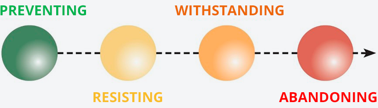
Four types of action to mitigate damage affecting the building are distinguished: PREVENTING the water from reaching the building; RESISTING the entry of water into the building after it has arrived outside it; WITHSTANDING incoming water while taking steps to minimise damage, and ABANDONING use of the building when the risk is too high.
Figure 9. Measures intended to offset damage in the building.
Source: Guide to reducing the vulnerability of buildings to flooding. Directorate General for Water and the Consorcio de Compensación de Seguros.
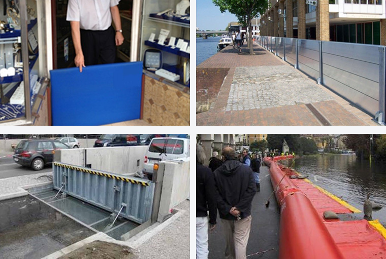
The most usual step is to deploy temporary barriers. For them to be effective, they will have to meet a set of requirements: a height above the highest level of flooding envisaged, water-tightness, resistance to both water pressure and the impact of water-borne objects, and availability, of both time and enough resources to move them into place. Other typical measures are non-return systems to head off flow-backs of sewage or bail-out pumps to evacuate build-ups of water and cut the time flooding is present and ensuring the continuity of available electricity in the event of black-outs by using uninterrupted power supply (UPS) units.
Figure 10. Examples of temporary barriers. Removable (Source: CAG Canalizaciones), stackable (Source: Flood Control International), collapsible (Source: Aggéres), inflatable (Source: Tandem HSE).
Then there are three different types of action to mitigate damage to equipment: RISING (lifting the exposed item over the flood level), RELOCATING (moving it to a non-exposed area) and PROTECTING (keeping it where it is and taking the necessary steps to limit damage).
Economic appraisal: A cost/benefit analysis is performed to convey how appropriate it would be to invest in prevention using the methodology outlined in the Guide to reducing the vulnerability of buildings to flooding.
The calculation is made by taking into account building and equipment damage, as well as the loss from business stoppage. Losses are worked out according to the percentage affected for 0.5, 1.5 and 3 metres of flood depth. Based on this information and using a proportion parameter, several risk hypotheses are considered subject to return periods of 10, 100 and 500 years and the different depths involved. By applying a mathematical model that incorporates loss levels and frequencies we can obtain the average annual loss and then multiply it to arrive at the potential cumulative loss over 30 years. Using these determinants, separate preventive strategies are proposed along with their estimated cost of implementation. Lastly the residual loss or estimated value of the loss after taking the set of preventive steps is calculated and the reduction in risk and the cost/benefit ratio which each alternative offers is studied.
5. Pilot cases for adapting to flood risk: examples
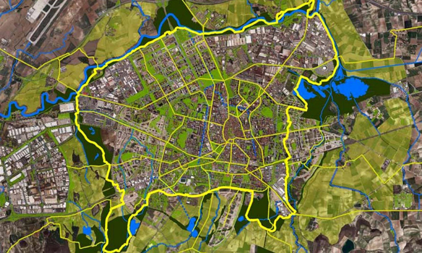
Resilience to flooding: Fraga (Huesca)
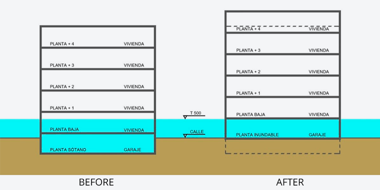
Fraga (Huesca, 14,979 inhabitants) is a stark example of urban occupation of a flood plain. The locality has recorded recurring river surges, notable among which are the 1982 event and recent, less severe incidents in 2010, 2013 and 2018. In response to this situation, Special Amendment No. 50 of Fraga’s City Master Plan (PGOU for the Spanish) brings limitations regarding flood risk into the municipal regulations.
Figure 11. Regulation of the floodable floor established in Amendment 50 of the PGOU. Essentially involves leaving the ground (floodable) floor for parking space and not for housing in multi-storey buildings of new construction, eliminating underground garages and also removing residential properties from the ground floor.
Source: Fraga Council.
In this case the methodology has been used which features in the guide named Assessment of the resilience of urban population centres to flood risk: networks, urban systems and other infrastructure, to find out which are the critical items which, if they ceased to be operational, might jeopardise the functioning of the rest of the urban network. Based on the mapping information available from the Download Centre at the National Geographical Information Centre (CNIG for the Spanish) we can obtain the inventory of Fraga’s networks, urban systems and other infrastructure. Superimposing these on the hazard maps available from the SNCZI allows us an overview of the locality’s adaptation requirements.
New uses that are compatible with floodability levels in the zones most at risk are suggested to boost resilience. On the other hand, several elements of the water supply and drainage/sewage network, power grid and transport system that need adaptive action are identified. There are also a large number of equipment items in the flood zone which could present crowded areas of population and hamper evacuation tasks in any emergency, which means they should organise their own self-protection plans. Likewise, through applying the concepts outlined in the Sustainable Urban Drainage Systems guide, assorted components of the landscape are flagged for potential integration with ecological connectivity criteria in urban development, with several examples of scope for benefit being described from a green and blue infrastructure standpoint.
Figure 12. Urban resilience in Fraga: graphic analysis.
Source: Own research based on information from the CNIG and the SNCZI.
An illustrative economic appraisal has been made of the measured intended to prevent and withstand water coming into the health facility, the day centre and an infant and primary school. Given that these are basic buildings, the cost/benefit analyses return only modest results compared to other categories. Even so, they should be prioritised for adaptation in view of the vulnerability posed by the use made of them and the characteristics of those inside.
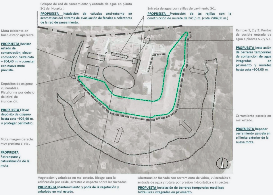
Recoletas Hospital/Carehome (Cuenca)
This is located where the river Júcar meanders through Cuenca, a zone prone to frequent flooding and often-varying river levels. The pilot study applies the concepts set out in the Guide to reducing building vulnerability to flooding and the guide offering Recommendations for constructing and fitting out buildings in flood zones as it seeks to diminish the building’s flood risk by consummating the courses of action in the Project to lessen flood risk and enhance the ecological condition of the rivers Júcar and Moscas as they pass through Cuenca, which proposes setting back the raised boundary on the right bank to yield more space to the river.
The visit allows determination of the points where water might enter and the potential flood damage. Firstly, the general sewerage network is on a level similar to the river surface, meaning that, when floods happen, it breaks down and there is a flow-back of waste water. The ventilation grilles in the outside flooring, the spaces hollowed in the façade that are vulnerable to breaking and letting in water due to hydrostatic pressure or the impact of water-borne items, as well as the entry ramps to the basements are other points that require adaptation. On the other hand, there are various facilities that would be compromised in the event of flooding which would put the vital services at the centre out of action.
Implementing non-return systems definitively addresses the set of problems associated with the sewage network. Furthermore, building low surrounding protective walls and parapets is advised, as well as installing collapsible hydraulic floodgates built into the flooring. Lastly, the electricity, air-conditioning and domestic warm water systems, as well as the oxygen supply and other vulnerable equipment need to be moved upstairs.
Figure 13. Cuenca pilot case: diagram summarising the proposal.
The new raised boundary protects the building up to the flood with a 25-year return period. For bigger surges, supporting adaptive measures have to be tackled. The estimated loss that would be generated by a river surge that reached the building amount to 920,000 euros, whereas the approximate cost of the measures is 197,000 euros.
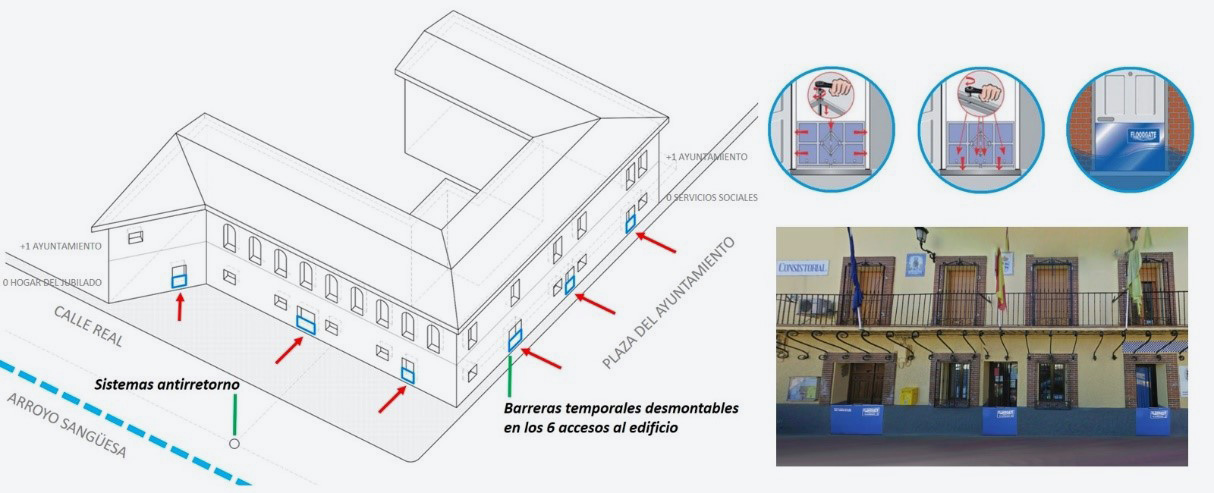
Cebolla Town Hall (Toledo)
The municipality of Cebolla (Toledo, 3,263 inhabitants) has suffered several bouts of flooding over the past decade. Notable for its severity was the event on 8 September 2018, where the loss incurred meant for Consorcio de Compensación de Seguros opening 173 case files and represented a cost of 639,180.28 euros. The predominance of olive and fig-tree farmland upstream, with a steep slope and no measures to control the run-off and erosion, gives rise to dramatic changes in fluvial dynamics. On the other hand, the underground canalization of the Sangüesa stream and its lack of ability to run through the urban stretch of its course cause a build-up of items that block it and make it overflow in situations where there is a sudden increase in the volume it has to carry.
Cebolla town hall is located in the high street of the main population centre, where the steep slope causes water overflows to run at great speed. It is a basic building with loadbearing brickwork walls and wood slabs but, in the event of a flood, certain emergency protocols are triggered there, which means that if it is out of action, this could lead to indirect loss as regards the municipality’s activities.
If we assume that any river surge will bring water into contact with the façade of the building, it is suggested that temporary barriers are used at the six entry points to the building to resist against water coming in. A possible solution is to deploy devices that consist of a steel frame that opens up over a horizontal and vertical plane and is encased in a neoprene covering to form a water-tight seal. These are easy and quick to set up and remove and can be fitted to a range of measurements. They need to be adjusted to ensure they are waterproof but they do not need any previous construction work. Installing non-return systems is also recommended.
Figure 14. Cebolla pilot case: diagram summarising the proposed solution. Inset: removable barriers (Source: CAG Canalizaciones) and an example of how they are used with the building.
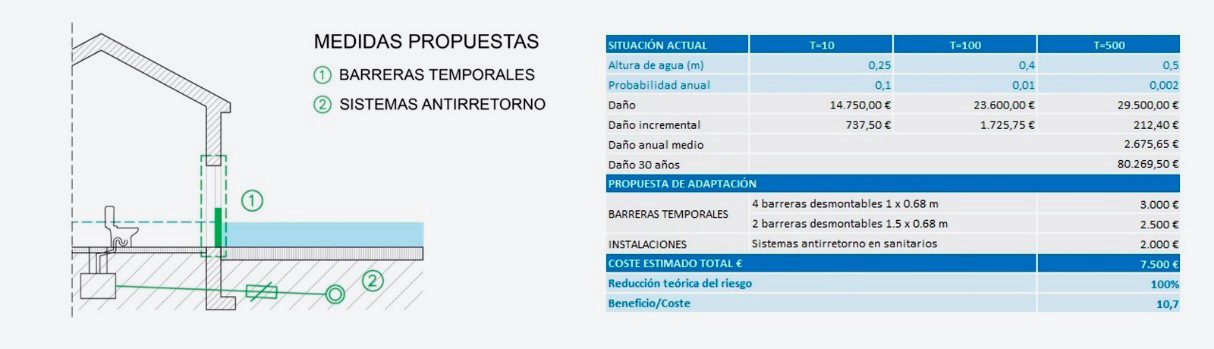
The package of measures costs roughly 7,500 euros. If we apply the methodology described in the guides, which factors in damage and its frequency, cumulative losses over 30 years are estimated to be over 80,000 euros. This gives us a cost/benefit ratio of 1:10.7.
Figure 15. Cebolla pilot case: cost/benefit analysis.
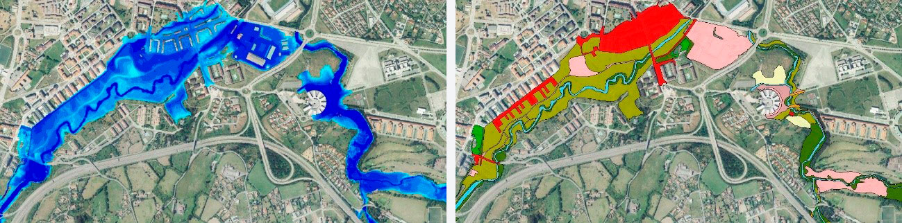
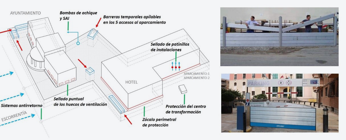
Los Alcázares Town Hall (Murcia)
The municipality of Los Alcázares (Murcia, 15,674 inhabitants), which is on the shore of the Mar Menor, a Mediterranean lagoon, has recently suffered several flood events which have resulted in heavy property and economic losses. Its town centre is in the area where the La Maraña ravine and several run-off and downpour overflow beds meet, which causes water to enter over a broad surface with no clearly-defined main channel. Moreover, the municipal district borders to the south with the El Albujón ravine, which overflowed during the event of 12 September 2019. The man-made disturbance to the landscape associated with farming and urban development has increased the vulnerability of the local area to flood risk. The situation is aggravated by phenomena such as cut-off (i.e. closed upper-level) lows and the higher frequency of events of this kind owing to climate change. This complex problem calls for integrated strategies which take into account resilience on several scales (building adaptation, hydraulic construction work, green and blue infrastructure, etc.) and also contribute to protecting and recovering the Mar Menor.
Los Alcázares has various different public features that are located in a flood zone. These include the town hall building, which already suffered a loss to a value of nearly 1 million euros in the event in September 2019, most of which focussed on the two underground carpark levels. Flooding of such areas is a recurrent phenomenon in flood events, for which reason the pilot case offers a scalable solution that can be reapplied to similar situations. It also allows us to show how pinpointing water entry points and taking relatively straightforward and inexpensive steps can prevent very serious losses.
The proposed solution centres on installing temporary barriers at the entrances to the parking area. The idea is to use light 20-centimetre aluminium panels that are positioned between guiding-grooves and supports built into a concrete base. They are installed on top of each other and automatically form a seal, thus offering the greatest possible protection and allowing high levels to be reached. It is also suggested that temporary sealing devices are used where there are ventilation holes and non-return systems at the main connection to the sewerage network, as well as a set of back-up measures for the neighbouring building (a business and hotel premises) which has a carpark in common.
Figure 16. Los Alcázares pilot case: diagram summarising the proposed solution. Inset: stackable barriers (Source: CAG Canalizaciones) and example of use with the building.
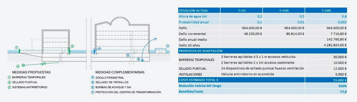
The waterlogging of underground carparks is a recurrent theme in flood events and the loss involved is very high, regardless of how deep the flood becomes outside. This pilot case offers a scalable solution that can be replicated in similar scenarios and which also allows us to show how pinpointing water entry points and taking relatively straightforward and inexpensive steps can prevent very serious losses. The cost/benefit analysis yields very promising results, whereby an estimated investment of 55,000 euros would avoid potential losses amounting to over 4 million euros over a 30-year period.
Figure 17. Los Alcázares pilot case: cost/benefit analysis.
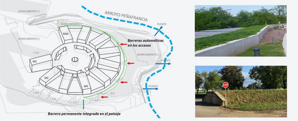
Multi-purpose building at the Gijón polytechnic school of engineering (Asturias)
On 11 June 2018, the multi-purpose building at the Gijón Polytechnic School of Engineering (Asturias) experienced a flood that derived from the overflowing of the river Peñafrancia, the surfacing of underground water and the heavy rains at the site. The occupation and narrowing of the flood zone, as well as a car-oriented urban development model which gives rise to additional obstacles and makes the ground water resistant, have created high-vulnerability conditions. This situation is currently aggravated by an upturn in the duration and frequency of strong storm events.
Given the complexity of the building, there are a whole host of potential water-entry paths. There have been notable rises in water via the small yard areas of premises due to the flooding of the space below the suspended flooring, which has occasioned large-scale loss across the entire floor-level.
The priority recommendation is to avoid the water reaching the building if there is a river surge by means of unbroken solutions that insulate its perimeter. If these should not prove feasible, an inventory should be made of all the vulnerable points and a complex programme devised consisting of one-off measures that is aimed at resisting against the entry of water. In this case, if any of the interventions fails or unforeseen points of entry appear, the proposed solution would be rendered invalid. On the other hand, given that the building is where significant research activity takes place and contains some very high-cost equipment and facilities, it is advisable to relocate the big-ticket items on higher floors that are not exposed.
Figure 18. Gijón pilot case: diagram summarising alternative 2. Inset: examples of permanent barriers blended in with the landscape.
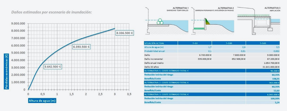
During the 2018 event, up to 80 centimetres of water flooded the ground floor of the building, causing estimated damage of 4.5 million euros. With no adaptive work, estimated losses over 30 years would be in excess of 30 million euros. Using inflatable temporary barriers, which are inexpensive, versatile and easy to install and store, offers a very advantageous cost/benefit ratio (of around 1:200). Nonetheless, they are dependent on both the action protocols working properly and a high degree of uncertainty with respect to the early-warning systems on account of the characteristics of the drainage basin. Another option, which is more costly, is building a permanent wall or barrier whose impact on the environment and the landscape can be offset by a response mix that combines engineering and nature-based solutions. This would be rounded off by installing automated barriers activated by means of sensors or water pressure at the access points. Lastly, a resilient building extension would be far more expensive but it would sort out the problem while also providing an increase in the school’s useful area. This is nevertheless subject to the limitations that can be inferred from Royal Decree 638/2016 of 9 December.
Figure 19. Gijón pilot case: cost/benefit analysis.
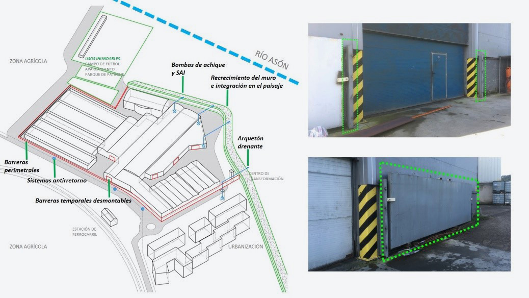
Marrón industrial estate (Ampuero, Cantabria)
The Marrón industrial estate, which specialises in manufacturing automotive parts, occupies the area between where the river Asón meanders as it passes through Ampuero (Cantabria, 4,219 inhabitants) and the Santander-Bilbao railway line, which is very vulnerable to flooding. The combination of heavy rains and the rise in temperatures that speeds up the thawing process in the mountains has triggered repeated surges in the past few years, most particularly on 31 January 2015 and 23 January 2019.
As a result of the serious event in 2015, the main company on the estate has implemented a contingency plan based on constant monitoring of the river course, special training for professionals and a set of self-protection measures (removable temporary barriers, non-return systems, bilge pumps and other specific actions) which made it possible to avoid business interruption throughout the 2019 event.
The problems involved concern overflowing and leakage through the retaining wall which borders on the left bank of the river as it runs through the locality. To support the measures that have been implemented this must be waterproofed and the possibility of raising it should be investigated, along with the potential repercussions of doing so by performing the relevant hydraulic modelling tests. Building drainage collection chambers is also advised to facilitate pumping efforts and allow the water to be emptied out effectively, as well as closing up the perimeter of the estate using temporary or permanent barriers to avoid water coming from other points in the case of extreme events.
Figure 20. Ampuero pilot case: diagram summarising the proposed solution. Inset: removable temporary barriers.
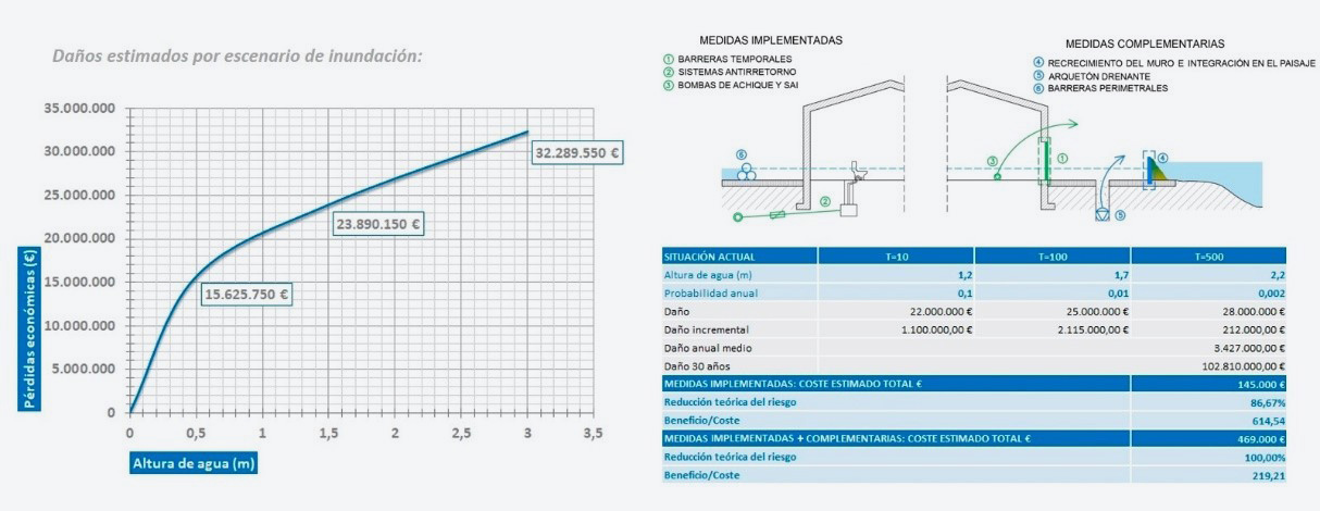
During the 2015 event, the water reached as deep as 1.70 metres inside the industrial premises and caused 25 million euros of losses for the main company on the estate, including the damage to the buildings, machinery, facilities, goods and loss from business stoppage. The programme of measures implemented cost 145,000 euros; even though the protection it affords is not total and calls for a substantial effort in terms of planning and self-organisation, it presents a distinctly encouraging cost/benefit ratio of around 1:600.
Figure 21. Ampuero pilot case: cost/benefit analysis.
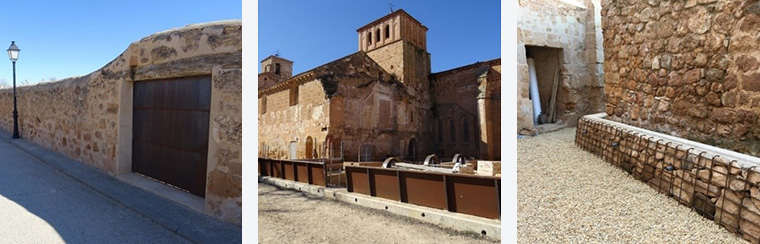
Santa María de Huerta Monastery (Soria)
Ever since antiquity, owing to highly localised rainfall phenomena, Santa María de Huerta (267 inhabitants, Soria) has experienced surges in the volume of water passing through the gullies that flow into the river Jalón, which produces flash floods that bring serious consequences for the town centre. Farming-related transformations to the drainage basin and the presence of both artificial hindrances and hydraulic construction work that lacks capacity aggravate the problem today.
The Santa María de Huerta Monastery is an example of Cistercian architecture and was built between the 12th and 16th centuries. It was listed as a site of cultural interest, when it was graded as a monument, and is a key part of the cultural heritage of Soria and Castile-León. On 23 June 2015 the collapse of the Tejar gully broke the perimeter wall going through the cemetery, although there was only limited damage to the monastery. Another event on 9 September 2018 again knocked down the enclosure, which caused water to burst inside dragging along stones and other objects with it. Inside the building the water rose to over a metre deep in the church, refectory, hall of the converts, cloisters and other rooms. At the same time the flood affected several refitting and digging undertakings.
Even though the site of cultural interest embraces the entire premises, the pilot case considers studying compatibility between protecting cultural heritage and floodability by differentiating between and prioritising the separate elements. The idea is to avoid water coming into contact with the monastery, the cemetery and the archaeological remains so as to ensure their preservation and to accept the controlled flooding of a portion of the premises in the event of a surge. This way any sudden bursting of the wall that might speed up the water current and the damage caused is prevented, while this works in favour of hydraulic transparency by flattening out the flooding over a surface area so that the flow has been weakened by the time it arrives at the town centre.
After the 2018 event, a package of emergency measures valued at 400,000 euros was established, including (among other repairs and preventive action) installing floodgates in the perimeter wall to evacuate the water from inside the enclosure, building a metal wall to stop the water touching the building and upgrading the drainage.
Figure 22. Santa María de Huerta: implemented measures.
The pilot cases for adapting to flood risk allow the following general conclusions to be drawn:
In Spain, flooding represents the natural risk that causes the most significant harm in terms of both property and human life. In light of this, adapting buildings can make a substantial contribution to keeping economic loss down and boosting the safety of those inside.
These measures should not be taken to be in isolation, but instead within the context of integrated strategies that allow us to increase resilience and face up to future hydro-meteorological determinants. As a means of complementing long-term territorial transformations, adapting buildings offers ready answers to events for which no response capability exists in current circumstances.
Land planning and exposure reduction in cities and communities represent the main preventive measures, although investing in these kinds of palliative measures, which are relatively inexpensive and straightforward, can be a way to avoid very severe losses.
Dissemination on all levels is key to fostering a risk culture. Shared responsibility and both public and private commitment must be encouraged, thereby involving all stakeholders and promoting incentives to stimulate adaptation.
Cost/benefit analyses return highly favourable results for certain case types, such as underground carparks, where a small investment avoids many forms of loss, or research centres and industrial estates, given the high economic impact of business interruption and because they are locations where very costly equipment is kept.
Strategic infrastructure which, if put out of action, could compromise the rest of the urban network; the components allocated for sanitation, public residences and teaching centres, on account of the vulnerability posed by their purpose and the characteristics of their occupants; institutional buildings where specific emergency protocols are triggered; or the cultural heritage, given the importance of what it symbolises and the identity value it has, must also be adapted.
Cost/benefit analyses must therefore be rounded off using new qualitative and quantitative indicators and factor indirect benefits from adaptive measures into the appraisal, including new environmental, economic and social values.
References
CEPRI, the European Centre for the Prevention of Flood Risk (2014). Comment saisir les opérations de renouvellement urbain pour réduire la vulnérabilité des territoires inondables face au risque d’inondation? Principes techniques d’aménagement.
FEMA (2014). Homeowner’s Guide to Retrofitting. Six Ways to Protect Your Home From Flooding, 3rd Edition.
García García, M. (2016). Desmontando la paradoja de la sostenibilidad. Revista Ambienta. 116. 4-22.
Marañón, B. (2019). Planificación y gestión del sistema hidrológico de Vitoria-Gasteiz en clave de infraestructura verde ("infraestructura azul"). Revista de Obras Públicas. 166. 21-26.
Ollero, A. (2014). Guía metodológica sobre buenas prácticas en gestión de inundaciones. Manual para gestores. Contrato del río Matarraña.
Perales-Momparler, S., Valls-Benavides, G. (2013). Sistemas de Drenaje Sostenible (SuDS). Revista Paisea. 24. 68-75.
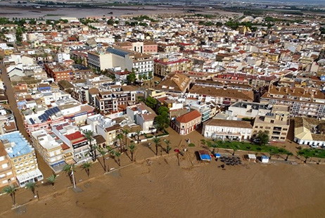
Figure 1. Flooding in Los Alcázares (Murcia) in September 2019.
Source: Segura River Basin Authority.