Volcanic activities in the Japanese archipelago
With 111 active volcanoes, Japan ranks 4th in number, after the United States, Russia and Indonesia. Although Japan’s share of global land area is 0.25 %, it houses 7 % of active volcanoes.
The Japanese archipelago is situated where four tectonic plates meet, which describes why earthquakes and volcanic eruptions occur so frequently. Active volcanoes are aligned with the plate boundaries, and many of which are found in parallel to the trench formed by the Pacific Ocean Plate sinking underneath the Japanese archipelago. Similar alignment is visible along the Nankai Trough formed by the Philippine Ocean Plate. There are three types of eruptions, namely magmatic, phreatomagmatic and phreatic eruptions observed. In terms of volcanic products, they are classified in seven types; volcanic ash & lapilli, ash deposits, volcanic gas, debris & mud flow, lava flow, pyroclastic flow, and sector collapse & debris avalanche.
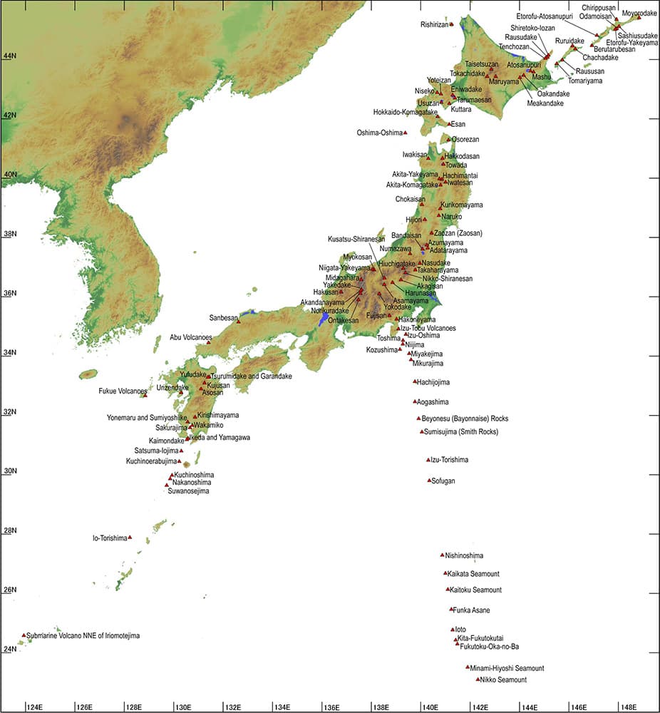
Figure 1. Active volcanoes in Japan.
Source: Japan Meteorological Agency (JMA).
Volcanic warning system in Japan
Out of the 111 active volcanoes, 47 are subject to constant surveillance and observation.
Japan Meteorological Agency (JMA) defines five Volcanic Alert Levels based on the target area and actions to be taken which are described using actionable keywords.
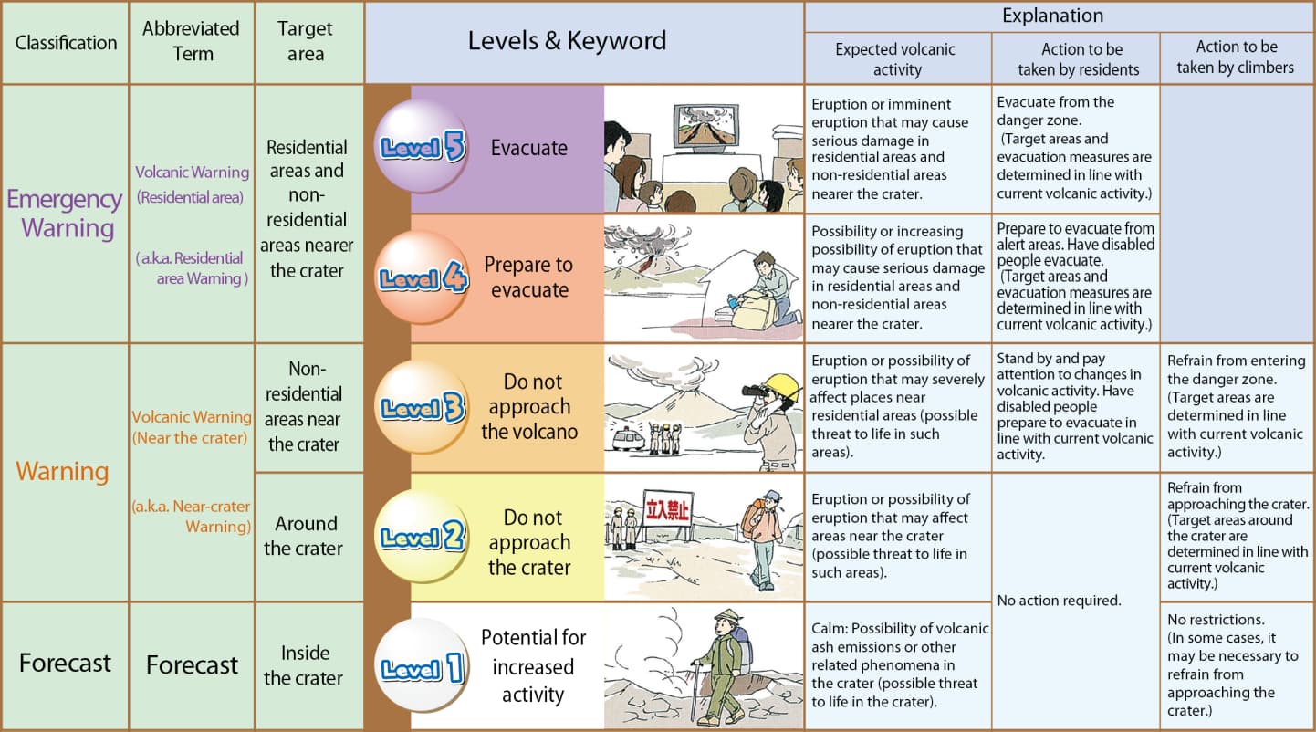
Figure 2. Volcanic Alert levels.
Source: JMA.
At Alert Level 5, there is a risk of massive eruption that calls for an evacuation. Currently, there is no volcano with Alert Level 4 or 5. There are three classified as Level 3 and five classified as Level 2.
Major historical volcanic eruptions and lessons learned
The following three eruptions are notable cases which prompted policy discussions.
Unzendake
Unzendake, located in the Nagasaki prefecture in Kyushu Island, has been active for 500 thousand years. In modern days, the vapor eruptions occurred between 1990 and 1991 are remembered. Most notably, the eruption on 3 June, 1991 accompanied large amount of pyroclastic flow which traveled in excess of 100 km/h, leading to 43 fatalities. Volcanic ash-turned debris flow that followed caused serious damage to the nearby township. At one point, the debris flow flooded 579 households. Volcanic ash reached not only the city of Shimabara but also Nagasaki.
Prior to the event, the destructive nature of the pyroclastic flow was little known. As it turned out, pyroclastic flow extended to an area broader than ash deposits. The situation forced local residents to evacuate, and its peak, the number of evacuees reached 11,000. It was only in 1995 that eruption ceased, by when 9,400 pyroclastic flows were observed. It prolonged the days needed for evacuation.
The number of fatalities is often cited to emphasize the tragic nature of the event. However, it should be noted that the director of the observatory appropriately released warning to the local residents one week prior to the event which saved the lives of 200 to 300. The victims were those who knowingly stayed in the hazardous area despite the warning. Therefore, the event is recognized as a case which proved the value of effective volcanic risk management.
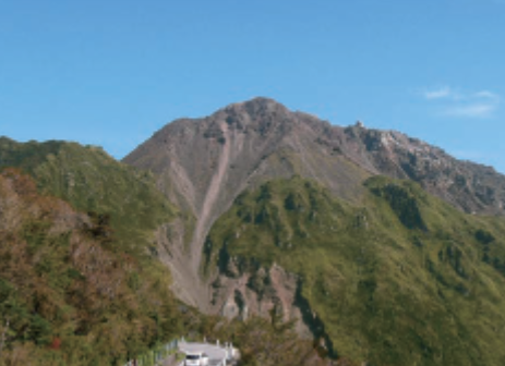
Figure 3. Unzendake.
Source: JMA.
Usuzan
Usuzan is located in the south-western section of Hokkaido, the northern-most island of the archipelago. It is known to have existed for around 110 thousand years. In recent decades, it erupted on 31 March, 2000, followed by another the day after at a different section of the volcanic system. Collectively, the events caused damage to manufacturing facilities and residential properties in the local township, forcing approximately 16,000 residents and tourists to evacuate. The alert was made in time for the evacuation, leaving no case of injury or fatality.
The successful conduct of evacuation is attributed to the inherited knowledge of the precedent that earthquakes occurred prior to eruption and the existence of dedicated volcanic scientists who played a critical role in alerting local government offices in a timely manner.
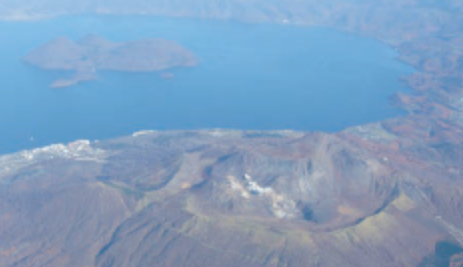
Figure 4. Usuzan.
Source: JMA.
Ontakesan
The biggest lesson Japan has learned over the recent decades is the eruption of Ontakesan, which is situated on the border of the Nagano and Gifu prefectures in the central part of Honshu Island. On 27 September, 2014, Ontakesan erupted and left 63 people deceased or missing, making it the worst fatal eruption post World War 2. As a famous climbing spot, there were more than 200 climbers around when the eruption occurred. It took the form of phreatic eruption which is considered less predictable in comparison to magmatic eruption. Reportedly, increase in volcanic earthquakes was observed between 10 and 11 September, 2014, which led to the issuance of “Explanatory information on the state of volcanic activities.” As there was no other irregular symptoms besides earthquakes, no change was made to the Volcanic Alert Level 1 “normal,” which was actually defined as “calm in terms of volcanic activity, however dangerous in the crater.”
The tragic event prompted the launch of the Working Group on Promoting Volcanic Disaster Prevention Measures, convened by the Central Disaster Prevention Conference’s Disaster Prevention Execution Committee. The Working Group responded by proposing remedial measures to the volcanic disaster prevention system, which was published on 26 March, 2015. The proposals covered the following six themes; 1) enhancing national volcanic risk management system, 2) strengthening observation capabilities and upgrading technical evaluation methodologies, 3) implementing a clearer disaster communication system, 4) introducing an appropriate evacuation protocol, 5) promoting education and knowledge sharing on volcanic eruption risks, and 6) strengthening research on volcanoes and developing human resources.
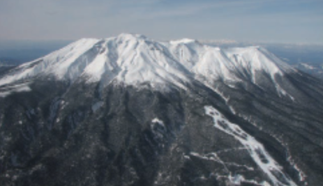
Figure 5. Ontakesan.
Source: JMA.
How insurance coverage is offered
In Japan, volcanic eruption risks are covered in conjunction with earthquake risks, although there are some exceptions. Most notably, volcanic ash is typically excluded under commercial property extensions, as insurers tend to avoid overwhelming accumulation of the said risk. The chart below summarizes how volcanic eruption losses are covered under major lines of business.
| Line of Business |
Coverage Part |
Volcanic Ash |
Other than Volcanic Ash |
Description on Volcanic Ash coverage |
| Commercial Property (Coverage Extension) |
Endorsement |
Excluded |
Covered |
N/A |
| Residential Property (Fire following EQ) |
Standard |
Resultant Fire only |
Resultant Fire only |
Only losses resulting from fire due to attachment or accumulation of volcanic ash are covered |
| Personal Auto (Note) |
Endorsement |
Total Loss only |
Total Loss only |
There are cases where only total loss due to surface scratch or acidification are covered |
| Personal Accident |
Endorsement |
Covered |
Covered |
For example, health issues to eye, nose, throat or bronchus due to attachment or inhalation of volcanic ash |
| Marine Cargo |
Standard |
Covered |
Covered |
Losses to cargos such as completed vehicles due to surface scratch or acidification from volcanic ash are covered |
| Inland Cargo |
Endorsement |
Covered |
Covered |
Losses to cargos such as completed vehicles due to surface scratch or acidification from volcanic ash are covered |
| Aviation |
Standar |
Covered |
Covered |
For example, third party liability losses caused by engine malfunction or property damage resulting from suctioning volcanic ash |
Note: Only in case where endorsement on total vehicle loss from earthquake, volcanic eruption and tsunami is in place.
Figure 6. Insurance coverage for volcanic eruption risks in Japan.
With limited cases of catastrophic volcanic eruptions since the initiation of commercial insurance business, there has been no recorded case where insurance payment has generated public debate. Nevertheless, volcanic eruption risks, particularly ash fall, can cause widespread economic loss, whose potential impact calls for close attention in terms of risk assessment and accumulation control.
Assessment of volcanic eruption risk
Based on the understanding that volcanic eruption can cause wide-scale socio-economic damage, the insurance industry in Japan has been conducting research over the years. The following description illustrates a study run by the General Insurance Rating Organization of Japan (GIROJ) in 2019. The study entitled “Assessment on the degree of volcanic disaster risk based on historical eruption” focused on two aspects; damageability per type of volcanic eruption loss, and volcanic hazard assessment based on historical eruption record.
Out of the 111 active volcanoes identified, the study focused on 86 volcanoes with relatively credible eruption record. It took into account 125,000 years of eruption record for large-scale eruptions (Volcanic Explosivity Index 6 and above) and 15,000 years for ordinary eruptions (VEI 5 and below).
The scope of volcanic phenomena covered volcanic ash, lava flow, debris avalanche and ash deposits for hazard assessment. In case of significant eruptions, they normally accompany several types of phenomena, such as volcanic ash, pyroclastic and lava flows. As such the study created hazard maps per each event. Having screened 86 active volcanoes, hazard maps for 105 eruption events representing 32 volcanoes were generated.
Damageability per type of volcanic eruption loss
In assessing damageability per type of volcanic eruption loss, the extent of damage to residential properties was classified in four categories; “total loss,” “massive loss,” “half loss” and “partial loss,” per each eruption phenomenon. As for pyroclastic flow, lava flow, debris avalanche and formation of crater, total loss damageability for both wooden and non-wooden structures are considered as 1.0. In terms of damage to buildings due to volcanic ash accumulation, probability of total loss to wooden structure was set as 1.0 for accumulation of 1m, 0.5 for 50 cm, 0.3 for 30 cm, and 0.1 for 10 cm. Figures for non-wooden structure was imported from flood statistics, with understandably smaller ratios for each. The degree of volcanic ash accumulation and damageability to structures is summarized in the chart below.
| Volcanic ash accumulation |
Typical consequences |
| 1 cm |
Driving a car becomes difficult. Public transportation is affected. |
| 2 cm |
Many people sense bronchial disorder. |
| 2-3 cm |
Public transportation system ceases. |
| 10 cm |
Damage to old wooden structures, such as roof collapse. |
| 20-30 cm |
Most wooden structures suffer from damages. |
| 50 cm |
More than half of wooden structures collapse. |
| 1 m |
Most wooden structures collapse. |
Figure 7. Volcanic ash accumulation and its consequences to structures.
Source: GIROJ.
Ash deposits have more destructive effect as they fall from high above. A sizable ash deposit can pierce through a residential roof which is likely to result in total loss. Probability of total structural loss due to ash deposit is summarized as follows.
| Distance from Crater |
Ratio of Total Structural Loss |
| 0-1 km |
0.17 |
| 1-2 km |
0.034 |
| 2-3 km |
0.0079 |
| 3-4 km |
0.00035 |
Figure 8. Ratio of total structural loss due to ash deposits.
Source: GIROJ.
Assessment on the degree of volcanic disaster risk based on historical eruption
Now that the hazard maps developed from historical eruption and damageability per type of loss are available, assumption on the number of damaged households per eruption event can be lead by applying a 250 m mesh number of household which is available from the Government census data. Dividing the sum of damaged households by the number of years of consideration (15,000 years for ordinary eruptions and 125,000 years for large-scale) yields the number of yearly damaged households. Applying the formula to all 105 eruption events, and summing up the results produces total number of damaged households per year. By denominating the result, national average degree of volcanic disaster risk can be obtained. The following chart summarizes the result.
| Category of Eruption |
Damaged Households (A) |
Annual Average Damaged Households (B) B=A/No. of years of consideration |
Annual Average Damage Ratio per Household (C)(per mille) C=B/D x 1,000 |
| Ordinary Eruption (No. of years of consideration: 15,000 years) |
2,939,256 |
196 |
0.0037 |
| Large-scale Eruption (No. of years of consideration: 125,000 years) |
69,572,590 |
557 |
0.0104 |
| Ordinary + Large-scale Combined |
- |
753 |
0.0141 |
| National Total Households (2015 Census) (D) |
|
|
53,331,797 |
Figure 9. Summary of volcanic disaster risk assessment.
Source: GIROJ.
Volcanic eruption risk management
Act on Special Measures for Active Volcanoes
As discussed in Section 3.3, the 2014 eruption of Ontakesan prompted national-level discussion to strengthen disaster risk management on volcanic activities, which culminated in the revised Act on Special Measures for Active Volcanoes. The Act consists of three pillars which are 1) redefining precautionary evacuation in volcanic disaster alert communities, 2) strengthening mutual co-operation among volcanic research institutions and development of volcanic expert resources, and 3) mandating local governments and climbers to exercise preventive effort by themselves.
On the first pillar that involves redefining precautionary evacuation, the national government retains the right to designate volcanic disaster alert district. Once designated, the relevant local government is required to set up and organize Volcano Disaster Prevention Council, comprising representatives from local government, local meteorological observatory, district development bureau, Japan Ground Self-Defense Force, law enforcement, fire marshal, volcano science, and tourism business. The Act also requires relevant local governments to define the following four items; 1) protocol to collect and disseminate information on volcanic activities, and alert the public, 2) elements to be incorporated as standards in municipal-level disaster prevention meetings, 3) issues to be considered in coordinating evacuation and rescue across community boundaries, and 4) other issues that involve precautionary evacuation system to prevent fatality or bodily injury from volcanic eruption in the designated alert district.
The second pillar requires both national and local governments to make effort in reinforcing facilities and organizations to conduct research and observation on volcanic activities in enhancing mutual cooperation among universities and think tanks in parallel to nurturing and securing human resources equipped with the needed expertise. It is also identified that the central government must promote research on scientific technologies in the field of predicting volcanic activities.
The third pillar focuses on climbers. The revised Act mandates not only relevant local governments to make effort in collecting information on climbers but also climbers themselves to gather information on the probability of volcanic eruption and to take measures necessary to enable smooth and expeditious evacuation at times of emergency including securing means to contact with local offices.
Currently 49 volcanoes, which involve 23 prefectures, are designated as disaster alert districts.
Advancing volcano research and human resources development
In response to the revised Act, the Ministry of Education, Culture, Sports, Science and Technology (MEXT) launched the “Integrated Program for Next Generation Volcano Research and Human Resource Development” as a ten-year plan starting in 2016. The program aims at promoting integrated volcano research encompassing observation, forecasting and countermeasures through unifying volcano observation data, and nurturing sound volcano researchers. The program focuses on developing four areas of expertise which are; volcanic observation data sharing system, cutting-edge volcano observation technology, forecasting technologies for volcanic eruptions, and volcano disaster countermeasure technology. In parallel to promoting researches, there is a project to form a consortium for volcano research and human resource development, since volcano researchers are scattered throughout the country.
Assessing the risk of ash fall
Despite the concentration of active volcanoes, the country has not experienced massive eruption that accompanies ash fall in modern days. However, the record tells that there were eruptions resulting in wide-area ash fall, such as Hoei eruption at Mt. Fuji in 1707 and Taisho eruption at Sakurajima in 1914. Nevertheless, the question of how to respond to potential challenges ash falls may bring about was left unanswered by the revised Act as discussed earlier.
To advance the discussion, the Disaster Management Implementation Committee of the Central Disaster Management Council established Working Group on Countermeasures for Wide-Area Ash Falls from Major Volcanic Eruptions in August 2018. There was growing concern over how highly industrialized and populated cities can maintain their function under accumulated ash fall. The Working Group was therefore tasked to study how city infrastructure may be affected by severe ash fall and what measures should be in place, to facilitate governments both national and local develop their disaster management protocols. The Working Group responded by publishing its findings in the report “Countermeasures for Wide-Area Ash Falls from Major Volcanic Eruptions -With Mt. Fuji’s Eruption as a Model Case,” which was released in April 2020.
The Working Group’s study was based on three hypothetical wind patterns following Mt. Fuji’s eruption. The existence of Mt. Fuji’s eruption record, including the one in 1707 which affected Edo, nowadays Tokyo, made it the choice of scenarios.
Learning from past experiences, likely impacts of ash fall on public services are summarized as follows.
| Railways |
Above-ground railways stop operating even with small amount of accumulation. |
| Roadways |
2-wheel drive vehicles are immobilized with 10 cm or greater accumulation under dry condition, or 3 cm or greater under wet condition. |
| Daily Necessities |
Food, drinking water and other essential items are sold out in populated communities. |
| Transportation |
Commuters are stranded due to paralysis of public transportation and resultant road congestion. |
| Electricity |
Power outage with 0.3 cm or greater accumulation under wet condition.
Even under dry condition, power generation is impaired with 2-3 cm accumulation. |
| Telecommunication |
Phoneline congestion occurs soon after eruption. |
| Water Supply |
Original water sources suffer from contamination, making tap water undrinkable. |
| Drainage |
Clogged drainpipe causes overflow of drainage. |
| Buildings |
Wooden houses collapse with 30 cm or greater accumulation under wet condition. |
| Human Health |
Irritation to eyes, nose, throat or bronchi. |
Figure 10. Impacts of ash fall on public services.
How to secure means of transportation is considered critical in the recovery process, which involves evacuation of inhabitants and delivering daily necessities. Under the wind pattern with the potential to affect the largest population and asset value, it would take three days before ash removing equipment reach essential public services to start sweeping arterial roadways.
The treatment of collected ash also needs to be figured out beforehand. Recent precedents saw ash disposed at designated waste treatment site or used for landfill. Under the worst case scenario, the amount of ash could be as much as 490 million cubic meters.
The report recommends relevant government offices and infrastructure operator to work closely with each other to put in place countermeasures to minimize losses and prevent social turmoil from happening.
Revising Mt. Fuji hazard map
Mt. Fuji Volcano Disaster Countermeasure Council was established in June 2012 by three surrounding prefectural governments, Yamanashi, Shizuoka and Kanagawa. The Council’s work has centered around revising Mt. Fuji hazard map which was originally prepared in June 2004 by national government offices in response to a series of low-frequency earthquakes observed underneath the mountain.
The revised Mt. Fuji hazard map has two components; a drill map which illustrates volcanic activities such as lava and pyroclastic flow assisted by numeric simulation, and a probability map which is an overlay of historical drill maps to visualize maximum spread and minimum arrival time of each volcanic activity in a comprehensive manner to depict the area with potential hazards.
As such, volcano hazard map is fundamental to crafting an effective means of disaster prevention. The Council therefore set up a three-year work plan to revise Mt. Fuji hazard map, and published the outcome in March 2021. The revision incorporated several upgrades such as; 1) increased the estimated crater range, 2) expanded the scope of historical study from 3,200 years to 5,600 years, 3) enhanced the granularity of topography to 20 m mesh from 200 m for lava flow and 50 m for pyroclastic flow, 4) increased the lava flow amount following massive eruption from 700 million cubic meters to 1.3 billion cubic meters, 5) increased the pyroclastic flow amount from 2.4 million cubic meters to 10 million cubic meters, and 6) updated historical record on sector collapse.
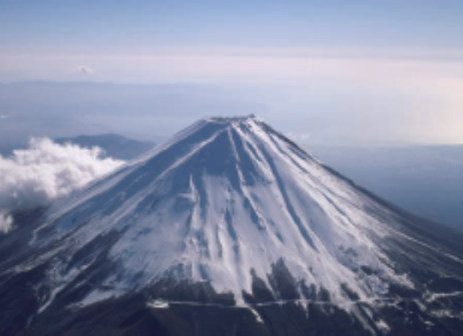
Figure 11. Mt. Fuji.
Source: JMA.
The state of predictive technologies
The Coordinating Committee for Prediction of Volcanic Eruptions, under the auspices of Japan Meteorological Agency and established in 1974, is composed of scientists and experts from public offices. The Committee convenes twice a year to update each other with activities of the 47 selected volcanoes. In the aftermath of the 2014 Ontakesan eruption, the Committee launched the “Study Group on the Systematic Volcano Observation” aiming at strengthening the monitor of active volcanoes. The Committee utilizes Global Navigation Satellite Systems (GNSS) which are useful in detecting precursors of an eruption by monitoring change in ground inflation or deflation of volcanic edifices which are driven by magmatic activity.
Future considerations
The unpredictable and case-specific nature of volcanic eruption risk makes it especially challenging for one to justify costs and resources to invest in advanced researches and hire dedicated experts to take precautionary measures against catastrophic events in the future. Even in Japan, it was under the Act on Special Measures for Active Volcanoes that recognized the importance of capacity building. The national effort to invest more in research and to nurture volcano researchers is a welcome step forward, however, deserves further public attention to scale up the effort.
The insurance industry has been accumulating knowledge in assessing volcanic eruption risk, both through industry organization and on individual company level. For instance, offering assistance to corporates and local municipal governments in designing their business continuity plan has been conducted as part of insurance companies’ daily business practice. Volcanic eruption has attracted greater attention among corporates operating in the Tokyo metropolitan area for their potential exposure to ash fall, which calls for an appropriate business continuity plan in place. It is expected that the industry contribute further to the national effort to better prepare for the next catastrophic eruption event by making the most of its risk evaluation capabilities.
References
- Japan Meteorological Agency “Volcano monitoring and disaster mitigation”.
- Working Group on Promoting Volcanic Disaster Prevention Measures “Promoting volcanic disaster prevention countermeasures based on Ontakesan eruption”.
- Working Group on Countermeasures for Wide-Area Ash Falls from Major Volcanic Eruptions “Countermeasures for Wide-Area Ash Falls from Major Volcanic Eruptions -With Mt. Fuji’s Eruption as a Model Case”.
- Ministry of Education, Culture, Sports, Science and Technology “Integrated Program for Next Generation Volcano Research and Human Resource Development”.
- General Insurance Rating Organization of Japan “Assessment on the degree of volcanic disaster risk based on historical eruption”.
- Act on Special Measures for Active Volcanoes.