
Volcanic hazard in Italy: a variegated landscape
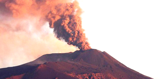
Cover photograph. Etna eruption in February 2021.
Source: Photograph by Boris Behncke.
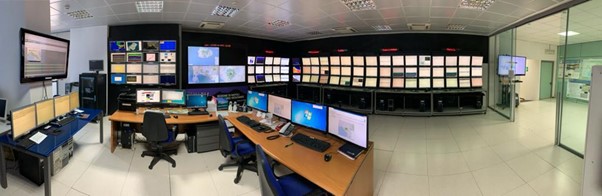
Figure 1. The monitoring room operating 24h/7d in Naples at INGV Osservatorio Vesuviano.
Source: www.ov.ingv.it. (opens in a new window)
A different kind of threat is posed by dormant volcanoes. These volcanoes have been inactive long enough to lose a direct connection with the magmatic system at depth and thus their capacity to erupt frequently. Nevertheless, these volcanoes maintain their full potential to erupt again in the future. With respect to frequently erupting volcanoes that have an open volcanic conduit, a renewal of eruptive activity at dormant volcanoes requires greater energy, and this may lead to explosive eruptions with a larger impact. Prolonged repose time may also contribute to reduce the risk perception among the local residents. People may peacefully live on the volcano slopes for decades and acquire a false sense of security that may hinder the implementation of long term mitigation actions.
The re-awakening of a dormant volcano does not pass unnoticed. The development of a new pathway for magma ascent toward the surface is generally accompanied by a number of geophysical and geochemical phenomena, such as shallow seismicity, ground deformation, and by changes in the composition and discharge rate of volcanic gases. These precursory signs may warn against the impending danger, and may directly threaten the local communities even before the eruption begins. Multidisciplinary monitoring networks enable to capture even small changes in observed parameters and the number and magnitude of observed anomalies help to constrain the current state of a volcano. Unfortunately, these precursors do not always provide actual clues on the duration and outcome of the ongoing unrest period. Volcanic unrest may terminate before magma reaches the surface, or may escalate into eruptive activity, and the entire process may take from a few days to several years. This large uncertainty about the final outcome and the time frame involved makes it really difficult to manage volcanic unrest. At this time (late November 2021), two Italian volcanoes are going through volcanic unrest: the Phlegraean Fields caldera, in the densely populated Neapolitan area, and the island of Vulcano, belonging to the Aeolian Archipelago. The volcanic unrest at these two volcanoes poses very different challenges to the community involved and emergency managers.
Other active but dormant Italian volcanoes are completely quiet, but their possible re-awakening must be accounted for in risk assessment. The most famous of these volcanoes is certainly Somma-Vesuvius, also located in the metropolitan area of Naples. Other quiescent volcanoes are the Island of Ischia, in the Gulf of Naples, two Aeolian islands (Panarea and Lipari), and Pantelleria, an island in the Sicilian channel. The list is completed by the submarine volcanoes in the Tyrrhenian Sea and the Sicilian Channel.
In the following, we describe significant features for the main volcanic areas in Italy and highlight the different problems posed by persistently active, unresting and dormant volcanoes. We believe they represent well many of the typical challenges related to volcanic risk assessment and mitigation.
Active volcanoes in Sicily
Stromboli
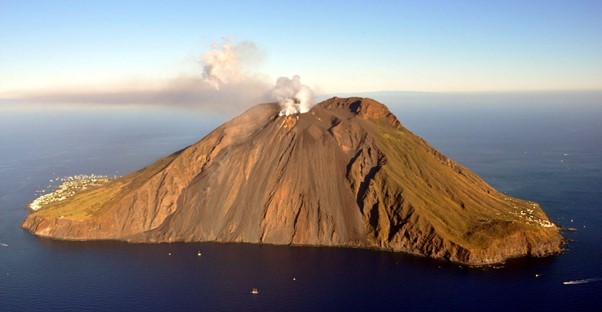
Figure 2. Stromboli Island, seen from the west. In the foreground, the erosive depression known as "Sciara del Fuoco". At the top, the summit craters which degases continuously. Bottom left, the town of Stromboli; bottom right, the houses of Ginostra.
Source: Photograph by Marco Neri.
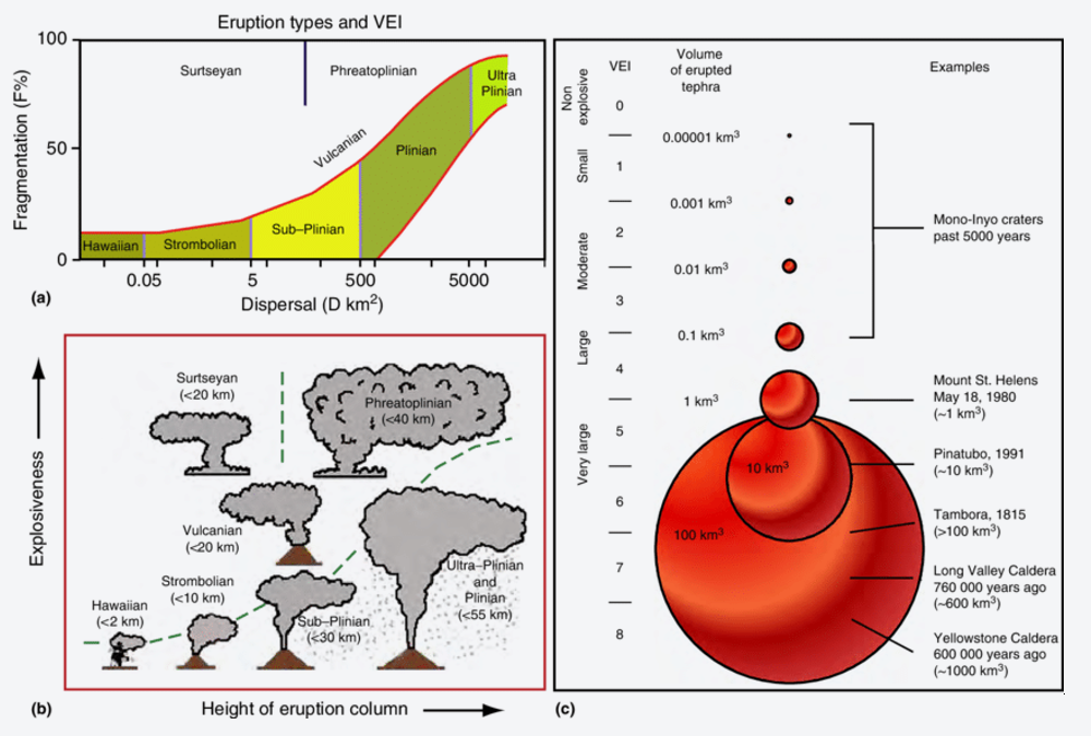
Figure 3. These diagrams show three different ways to classify explosive volcanic eruptions, according to a) the area of ash dispersion and the percentage of fragmentation of pyroclastic fall deposits; b) the height reached by the eruptive column and explosiveness degree; c) Volcanic Explosivity index (VEI).
Source: Hickson, Catherine & Spurgeon, T. & Tilling, Robert. (2013). Eruption Types (Volcanic Eruptions). 10.1007/978-1-4020-4399-4_122.
Etna
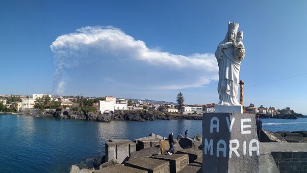
Figure 4. March 4, 2021: Explosive eruption from the Southeast Crater of Etna, seen from the Gulf of Ognina, in Catania. The eruptive column rises vertically for about 8-10 kilometres in height before being pushed by the wind towards the north-east.
Source: Photograph by Marco Neri.
All known Etnean flank eruptions have produced lava flows, many of which invaded areas of cultivated land, destroyed human property and infrastructures, and sometimes buried entire villages. In 1928, for example, the village of Mascali was almost totally buried and destroyed by the lava and rebuilt elsewhere, further downslope. On the other hand, during the past 70 years the urbanized areas around the volcano have rapidly developed, with an extensive system of lifelines and rapid growth of population centres, often in areas that have been covered by lava flows in the historical period. Tourist facilities have been established high on the volcano (up to 2,600-2,800 m high) and were repeatedly damaged by lava flows, most recently in 2001 and 2002-2003. For these reasons, the Etnean region is more vulnerable now than at any time before.
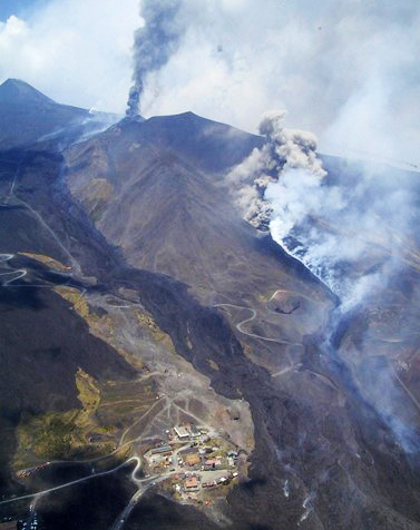
Figure 5. July 28, 2001: flank eruption of Etna. Lava flows invaded and destroyed part of the Etna-Sud tourist centre.
Source: Photograph by Marco Neri.
The vulnerability of the Etna area is well known by the populations who have lived on its slopes for thousands of years. However, people consider Etna to be a "good volcano", as it hardly ever claims victims, with its lava flows that move slowly enough to allow people to escape. The alert level for Etna is currently yellow.
Vulcano
Since the last eruption, Vulcano has gone through periods of unrest characterized by an increase of fumarolic activity and gas discharge, both at the fumarolic field on the crater rim and at the base of the cone. Between 1988 and 1993, in particular, a notable increase in the temperatures of fumarolic gases was observed; up to 690° C. Heating was associated with changes in gas composition, suggesting an increased magmatic contribution. With time, all the anomalous signals returned to their background values and the unrest ended without a renewal of eruptive activity. More recently, since September 2021, the INGV monitoring systems have highlighted changes of geophysical and geochemical signals, including shallow seismicity, ground deformation of the crater area, changes in gas composition, temperature and discharge rate (Figure 6). Some inhabited areas have been affected by anomalous gas discharge through the soil, and the evidence of dangerous concentration of volcanic gases in air prompted a temporary ban to overnight in those areas. Based on the changes described above, the Department of Civil Protection has ordered the transition of the alert level from Green to Yellow for the island. Very recently, the framework related to the alert levels that describe the volcanic state of activity by a combination of monitoring parameters and data collected to any ongoing events, has been re-defined through a close collaboration among INGV, Civil Protection and some Universities. In the new scheme, the yellow level corresponds to unrest of the hydrothermal system that feeds the fumaroles.
Different hazard scenarios are possible on Vulcano, which is characterized by a long-standing history of eruptive activities and a geothermal system that has been active since historical times. Some hazardous phenomena from La Fossa cone are also possible due to the slopes instability, strongly influenced by either the volcanic dynamics or hydrothermal activity, as seen in many other tuff cones. The potential renewal of volcanic activity from La Fossa (or caldera rims) carries a high risk especially for the more inhabited northern sectors of the island, which are crowded by thousands of tourists during the summer and located just at the foot of La Fossa cone.
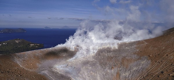
Figure 6. La Fossa crater on the Vulcano island and, in the background, the islands of Lipari, Panarea and Stromboli in November 2021.
Source: Photograph by Gianfilippo De Astis.
The active volcanoes in the Neapolitan area: Somma-Vesuvius, Phlegraean Fields and Ischia island.
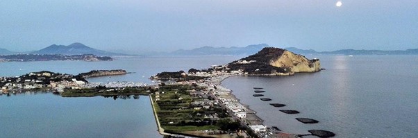
Figure 7. The Somma Vesuvius volcano in the background and the tuff cone of Capo Miseno, in the Phlegraean Fields caldera, in the foreground.
Source: Photograph by Fabio Sansivero .
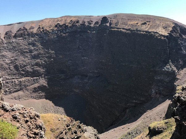
Figure 8. Inside the Vesuvius crater.
Source: Photograph by Giuliana Alessio.
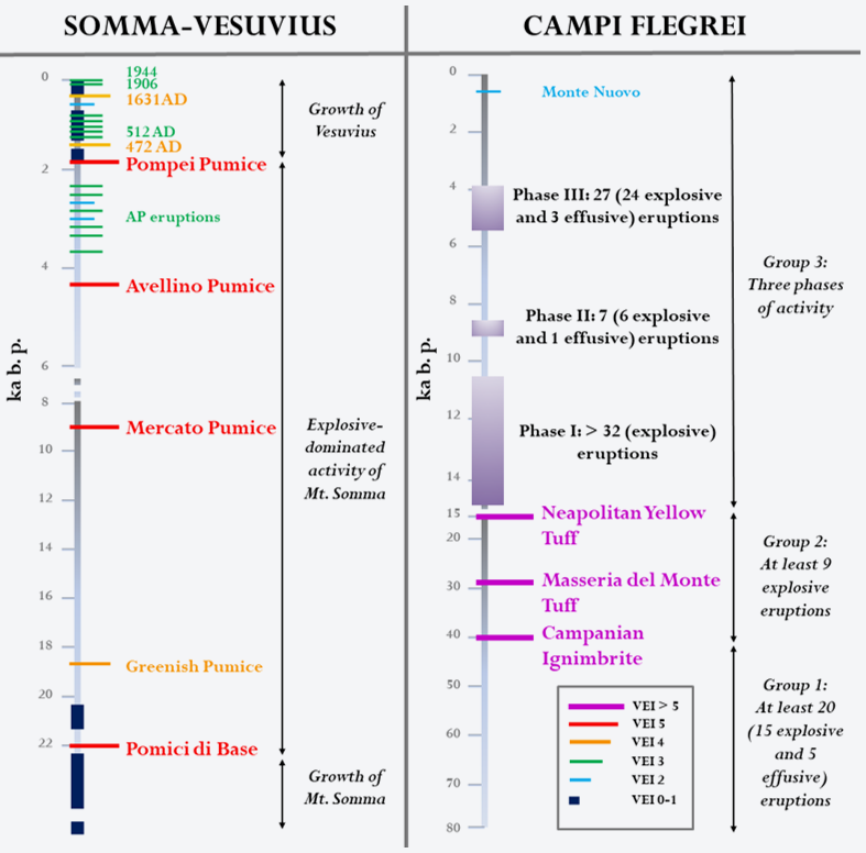
Figure 9. Schematic chronograms of volcanic activity of Somma-Vesuvius and Phlegraean Fields as recorded by stratigraphic successions. At Somma-Vesuvius in the last 22,000 years, four plinian caldera-forming eruptions and at least three major sub-Plinian eruptions occurred. The last cycle of open conduit activity started after 1631 and lasted until 1944. At Phlegraean Fields, volcanic activity started more than 80,000 years ago and includes the large caldera-forming Campanian Ignimbrite eruption and the second major caldera-collapse eruption of the Neapolitan Yellow Tuff. The only eruption in historical times occurred in 1538 AD. For Phlegraean Fields VEIs of the last 14,000 years eruptions are not indicated.
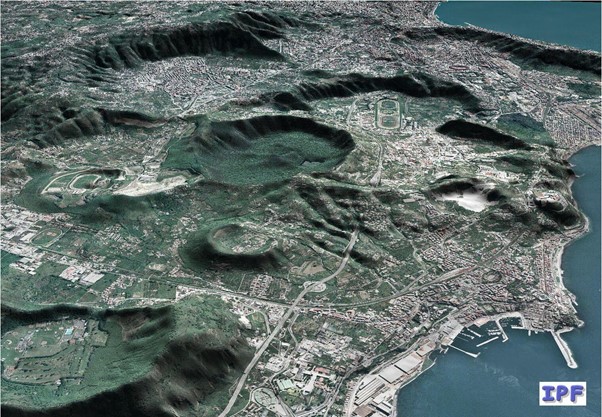
Figure 10. The figure shows part of the Phlegraean Fields caldera at whose centre is the city of Pozzuoli, in the foreground. Some of the monogenetic volcanoes formed during the last ten thousand years of volcanic activity are visible. The image shows the high urbanization of the caldera. In particular, in its centre, the crater of the Astroni (formed about 3,800 years ago), today a natural park and the Piana di Agnano from which the Plinian eruption of Agnano Montespina occurred (about 4,100 years ago); below on the left the bigger crater of Gauro (formed about 10,000 years ago).
Source: DTM by Laboratory of Geomatics and Cartography, INGV Osservatorio Vesuviano.
After a long period of subsidence following the last eruption, in the last decades the caldera showed signs of potential reactivation characterized by episodes of ground uplift, shallow seismicity, significant increase in hydrothermal degassing, and changes in fluid geochemistry (Figure 11). In the Phlegraean Fields caldera the characteristic phenomenon of the slow lifting or lowering of the ground is called bradyseism (Figure 12).
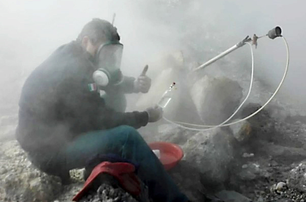
Figure 11. Sampling of fumaroles at Pisciarelli, in the Phlegraean Fields Caldera.
Source: Photograph by Emanuela Bagnato.
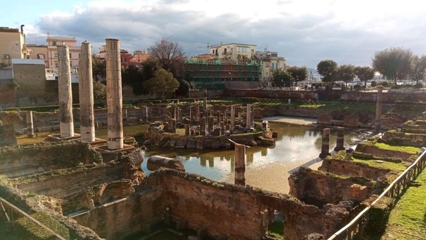
Figure 12. The Temple of Serapis, a Roman market located not far from the Pozzuoli coast line. The ruins of this Macellum (which dates back to the end of the 1st century AD) have been fundamental for the reconstruction of the ground movements (bradyseism, from the greek bradius = slow and seismos = movement), due to the presence on the three standing marble columns of lythodome’s holes (marine molluscs that live in a coastal environment at the limit between high and low tide) that testify the maximum subsidence of the area.
Source: Photograph by Fabio Sansivero.
Due to the high volcanic hazard and the densely populated urban context, the Neapolitan volcanoes have been the terrain to develop complex risk mitigation strategies aimed at emergency planning. Important information to forecast the future behaviour of the volcanoes derives by an accurate and in-depth analysis of the magmatic and eruptive history, as well as numerical simulations of expected eruptive phenomena. On this basis, the volcano science community has defined the possible pre-eruptive and eruptive scenarios of future eruptions and the areas that will eventually be affected by the effects of volcanic activity. In addition, the monogenic nature of the past Phlegraean Fields eruptive activity implies the uncertainty in the precise location of the future eruptive vent, a new volcano could grow at any place inside the 12 km wide caldera. This knowledge represents the basis for identifying the perimeter of areas potentially subject to dangerous phenomena, adopted in emergency planning by the National Department of Civil Protection in Italy.
The National Plans of Civil Protection for Somma-Vesuvius and Phlegraean Fields include as reference scenario for both the volcanoes, which is an explosive eruption of medium size. This scenario is characterized by three main stages corresponding to different hazard and risk areas: a first phase of "fallout", with the development of a very high (tens of km) and sustained eruptive column associated with the fall of pyroclastic fragments in the downwind sectors (the so-called yellow zone), a second phase of eruptive column collapse with generation of pyroclastic flows (affecting the so-called red zone) and a third phase with abundant precipitation and generation of mud flows.
The impact associated with the first phase consists mainly in the collapse of the roofs in the urbanized area around the volcanoes. At this latitude, stratospheric winds mostly blow eastward. This considerably reduces the hazard of ash fallout for the 1 million inhabitants’ city of Naples in case of an explosive eruption of Somma-Vesuvius, located in the eastern sector of the city. However, Naples is highly exposed to ash fallout produced by an eruption from Phlegraean Fields, located in the western sector.
Nevertheless, the maximum risk derives from the passage of pyroclastic flows (second phase). These are clouds of ash and volcanic gas that flow at high speed and temperature along the volcano flanks and can reach considerable distances in a few minutes, destroying everything along their path. In the areas closest to the vent, due to their high density and speeds (100 km/h), pyroclastic flows are able to knock down even modern reinforced concrete buildings. At greater distances the pyroclastic flows slow down and lose part of their ash load, so the impact force is reduced while the temperature remains always above the survival limits. Recent studies show, in fact, that during the Plinian eruption in 79 AD the unfortunate inhabitants of the towns of Herculaneum and Oplontis (located 5-6 km from Vesuvius), as well as those of Pompeii (10 km from Vesuvius), died of thermal shock due to the high temperature (300-600 °C) of the pyroclastic flows.
In case of medium-high intensity explosive eruptions, the pyroclastic flows coming from Phlegraean Fields and from Somma-Vesuvius can reach the city area of Naples, such as demonstrated both by the volcanic successions present in the metropolitan area, and by the results of numerical calculations that simulate the passage of pyroclastic flows on the current volcanic morphologies. Due to the high impact of pyroclastic flows, the only countermeasure for safeguarding the population remains the complete evacuation of the risk zone at the very onset of the volcanic crisis and before the eruptive phase occurs.
Despite the high volcanic hazard of the Neapolitan area, the resident population does not perceive the volcanic risk as relevant. In the last decades in-depth studies of volcanic risk perceptions have been carried out for inhabitants of the Neapolitan area. The results for the Vesuvius population demonstrates that people are aware of the threat of a future eruption and worried about it, but they feel more concerned by the problems they daily face, such as unemployment and crime. Moreover, 80 % of the sampled population believe that Vesuvius will not erupt within the next 10 years. The study also highlights that knowledge of the Vesuvius Emergency Plan is not widespread. Consequently, trust in public officials and in the success of the plan is low, as well as self-confidence to deal with such an emergency. On the other hand, a positive note is the great confidence in scientists. More recently, another survey has shown that Vesuvius Red Zone inhabitants are more aware about volcanic threat than Vesuvius Yellow Zone ones. This different perception was to be expected, given that they have been most affected by the Vesuvius eruptive activity in recent times.
For Phlegraean Fields caldera inhabitants, as for those of Vesuvius, volcanic hazard is not spontaneously mentioned as a major problem facing the community and is more associated with Vesuvius volcano than with the Phlegraean Fields caldera. However, when asked about the specific issue, citizens expressed serious concern about the volcanic threat and its effects on their community. Only 17 % of the population sample is aware of the existence of the Phlegraean Fields Emergency Plan, and 65 % said that they have not received enough information about the possible effects of an eruption. Nonetheless, citizens feel sufficiently confident in being able to face an eruption but have low confidence in local authorities and civil protection.
Finally, probably because an emergency plan has not yet been implemented, the volcanic hazard perception of a small sample of inhabitants of the island of Ischia is very low, so low that some of them believe they are included in the risk maps for Vesuvius.
All these issues pose a challenge to emergency management in the whole Neapolitan area and highlight the need of an accurate educational and raising awareness campaign about volcanic hazard and emergency plan, which builds knowledge, motivation and coping abilities. Moreover, for both Somma-Vesuvius and Phlegraean Fields areas, citizens ask for their involvement in emergency planning and in particular in preparedness measures. It follows that a participatory process should be established in the construction and update of future emergency plans.
Southern Italy is one of the most active tectonic and volcanic settings in the Mediterranean area, comprising persistently active and dormant volcanoes. As we write, two volcanoes feature a persistent eruptive activity: Stromboli, belonging to the Aeolian Archipelago, in the Tyrrhenian Sea, and Etna, along the Eastern coast of Sicily. Both volcanoes are usually characterized by mild explosivity featuring the launch of pyroclasts near the vent, occasional lava flows and lava fountains up to several hundreds of meters. This kind of activity may culminate in the development of eruptive columns, which may reach up to 10-15 thousand meters, in the case of Etna.