Volcanic hazard in Colombia
Colombia's terrain is extremely varied, ranging from low valleys to high snow-capped peaks. This is due primarily to the fact that the country is located right in the middle of the Pacific Ring of Fire, known to be one of the subduction zones that harbours some of the world's most important zones of seismic and volcanic activity as a result of the interaction between the Nazca and the South American tectonic plates. Its privileged location in the tropical region at the north-western tip of South America makes it the only country in this part of the continent with coasts washed by both the Pacific and Atlantic oceans.
In terms of area, Colombia spans nearly 1,143 million km² (twice the size of Spain), crossed by the Andes mountain range, which covers a large part of the territory, and the Amazon basin. The Andes mountain system divides into three ranges separated by the valleys of the Magdalena and Cauca rivers, the Western [
Occidental], Central, and Eastern [
Oriental] ranges, crossing more than 69% of the total territory (22 of Colombia's 32 departments).
All this makes our country one of the regions with the highest diversity of flora and fauna in the world, and its territory is host to the planet's largest extent of paramo, more than 3,000 species of butterflies, and 20% of existent bird species. This, its volcanic relief, and the large variety of high mountain climates impart great environmental value, evinced by a wealth of water resources and a high degree of biodiversity that lend beauty to its imposing landscapes.
Turning our attention now to the matter of volcanoes, this coffee-producing country is situated in the Andean Volcanic Belt, which as its name implies spans the Andes mountain range in Argentina, Chile, Bolivia, Peru, Ecuador, and Colombia. Most of the 23 active volcanoes in Colombia are located in branches of the Central range, with some in the Eastern range, displaying activity in the southern, middle, and northern regions of the country.
Many of the features associated with the volcanism inherent to the geological attributes of the country referred to above make the country an ideal location for ecotourism in the form of sporting activities like mountaineering and hiking, offering such attractions as hot springs and hiking trails, adding to the country's cultural richness.
Nevertheless, based on the latest population census statistics from 2018 released by the National Administrative Statistics Office [Departamento Administrativo Nacional de Estadística (DANE)] and on a set of over 165 hazard maps for Colombia, some 5.5 million people live at risk from volcanic activity in the country.
This figure has placed the important task of advancing our detailed understanding of volcanic perils on the radar of the government agencies charged with managing disaster risk with a view to being able suitably to define the vulnerabilities arising from the above-mentioned attributes and thus continuously to improve all those actions and measures aimed at managing volcanic hazard in Colombia.
Colombia's eruption history
Each volcano has its own individual characteristics that raise different challenges for managing disaster risks. Exposure and threat conditions and social and physical vulnerability of the areas within the regions of influence of volcanoes produce different risk scenarios that make it necessary to take measures designed to protect the lives of the country's inhabitants and to reduce the economic damage and losses that could ensue.
Two tremendous events stand out in the history of eruptions in Colombia. They have played a key role in recent years and involve two of the most dangerous volcanoes on the continent of South America, the Nevado del Ruiz Volcano and the Galeras Volcano.
The Armero tragedy: the Nevado del Ruiz Volcano
This natural catastrophe caused by the eruption of the Nevado del Ruiz Volcano on Wednesday, 13 November 1985, is one of the most important events in Colombia's history and the second-most deadly eruption of the twentieth century after the volcanic cataclysm of Mount Pelée on the French island of Martinique in May 1902.
The eruption affected Colombia's Departments of Tolima and Caldas, where the Nevado del Ruiz is found, and took the inhabitants of the areas surrounding the 5,321 m-tall giant by surprise. It melted around 10% of the glaciers, causing a lahar that rushed down the Lagunilla River, as it went burying and obliterating the entire town of Armero, a prosperous agricultural community located in the northern part of Tolima whose main crop was cotton.
This natural tragedy took the lives of more than 25,000 people and according to a study released by the World Bank with the Colombian Agency for International Cooperation and Colombia's National Planning Department [
Agencia Colombiana de Cooperación Internacional y el Departamento Nacional de Planeación (DNP)] cost the country 2.05% of its gross domestic product (GDP) at the time, the equivalent of 712.8 million US dollars at the average exchange rate of 142 Colombian pesos, that is, some 25.50% less than today
(1).
Total estimated damage came to USD 246 million, representing 0.70% of the GDP. Rescue and relief efforts cost USD 14.7 million (0.04% of the GDP); rebuilding nearly USD 360 million (1.02% of the GDP), and operating expenses have been put at USD 95.1 million (0.27% of the GDP). The study calculated that the cost of the impact on manufacturing totalled USD 84 million and damage to agriculture and livestock got close to USD 5 million.
In the wake of the eruption, the RESURGIR (Rebuild) Reconstruction Fund [
Fondo de Reconstrucción] was established on 24 November 1985 and put in charge of reconstruction measures. Its recovery plan came to nearly USD 316 million.
These figures, though by no means negligible, are far from the much greater cost of the loss of human lives taken by the tragedy. One of the most memorable, which has become a symbol of the victims of this natural catastrophe, was the death of Omaira Sánchez, a young girl just 13 years old whose legs were trapped under a wall. She struggled in the mud to hold onto life for three days but ultimately succumbed and was one of the victims whose bodies had to be recovered by rescue teams amid all the destruction.
This volcano has been active for about two million years and has gone through two major periods of eruptions to the present day.
The volcano is composed of layers of lava alternating with hardened volcanic ash and is located in the Los Nevados National Nature Park [
Parque Nacional Natural Los Nevados], which, together with the Nevado de Santa Isabel and Nevado del Tolima volcanoes and a series of craters, paramos, wetlands, and rainforests, is one of the country's largest volcanic complexes thanks to the geological features of the region and makes up one of Colombia's main tourism areas.
The volcano has been showing signs of activity for 11 years and is currently under a yellow alert, namely, there is no imminent threat of eruption. Still, at that alert level earth tremors, the ejection of ash, lahars, morphological changes, and venting of gases are common and certainly affect the quality of life of the populace living within its area of influence. Three events stand out in its history of eruptions: one in 1595 (160 victims), a second in 1845 (more than 1,000 victims), and the event recounted above in 1985 (25,000 victims).
The Galeras Volcano
The Galeras Volcano is found in Colombia's Department of Nariño, located at the southwestern tip of the country, just 9 km distant from the capital city (San Juan de Pasto). This volcano is considered to be the most active in the country and has a record of numerous eruptions over various centuries. It has been classified as one of the 16 most important volcanoes in recent times by the International Association of Volcanology and Chemistry of the Earth's Interior (IAVCEI)'s
"Decade Volcano" Project (Spain's Teide Volcano on the island of Tenerife in the Canary Islands is another on the list). This project was designed to promote the assessment and dissemination of studies on the activity of volcanoes with the potential to cause high losses because of their proximity to populated areas.
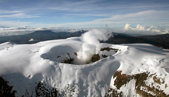
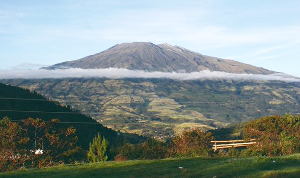
This relatively cone-shaped giant is not covered with snow or ice. It is a stratovolcano, which means that its structure is formed by a series of layers of material expelled by previous eruptions. Its age is put at around 4,500 million years and has been active for about 1 million years. It is the volcano with the most active recorded history in Colombia and is continuously expelling smoke and ash, and the population living in its vicinity has had to be evacuated on several occasions.
Since the 1990s the volcano has been exhibiting various minor eruption events, mostly volcanic in nature, culminating in the release of small flows of thick lava, gases, and ash. Precisely during one of these active periods, on 14 January 1993, a sudden eruption in the middle of an expedition into the crater cost the lives of six volcanologists and three tourists who were collecting gas samples directly in that spot, an event that is sadly memorable among experts, since in its aftermath eruption events were able to be relate to previous
tornillo seismic movements
(2).
Lessons learned, measures taken
The main eruption of the Nevado del Ruiz Volcano was preceded on 22 December 1984 (11 months earlier) by a reawakening in the form of a swarm of 30 tremors, 4 of which were felt according to reports by the region's inhabitants. This series of events gave rise to the establishment of a Nevado del Ruiz technical monitoring committee made up of various national public and private entities and even some international bodies under the direction of the National Institute of Mining and Geological Research [
Instituto Nacional de Investigaciones Geológico-Mineras (INGEOMINAS)] (now the Colombian Geological Survey [
Servicio Geológico Colombiano (SGC)]), which on its creation in 1968 had initially been assigned the task of systematically exploring and mapping Colombian territory.
A network of four portable analogue microseismographs had been installed in July 1985 (four months before the above-mentioned eruption). These recorded data on paper and had to be collected on site, and then an attempt to interpret the data had to be made. The state of technological progress and the relatively negligible experience with volcanic seismology at the time meant that the measurement and geochemical sampling results obtained before the volcano erupted proved to be insufficient for taking decisions and preventive action and measures. Nonetheless, the first version of what was then called the first specific volcanic hazard map to assess the state of activity of the Nevado del Ruiz Volcano was presented on 7 October of that same year. The map depicted high threat areas which included most of the towns that would subsequently be affected by the lahar.
The dearth of information leading up to the catastrophe led to the design and creation of a national disaster risk management policy and issue of a set of guidelines that together gave rise to the initial version of the National Disaster Risk Management System [
Sistema Nacional de Gestión del Riesgo de Desastres], which 33 years later has enabled the country to have in place a regulatory framework and a national disaster risk management policy. A series of national public, private, and community bodies have been set up and all work together under this policy. They have been provided with means, guidelines, and policies aimed at performing societal risk management designed to protect the population of Colombia as a whole. Chief among these is the Colombian Geological Survey (formerly
INGEOMINAS), the body charged with monitoring the country's active volcanoes at three volcanology and seismology observatories located in the cities of Manizales, Popayán, and Pasto.
One of the actions worthy of note undertaken subsequent to the Armero tragedy was the eruption of the Nevado del Huila Volcano on 20 November 2008, which caused a lahar that was up to twice as strong as the Nevado del Ruiz lahar. This time, although the flows of mud and debris swept down the Páez River and affected the town of Belalcázar in the Department of Cauca (in the southwestern part of the country), thanks to the institutions that had been put in place and the advances in technology that had been made, the volcanology observatory in the city of Popayán (Department of Pasto) had been able to record data ahead of the changes in the volcano. As a result, the community was able to put a series of measures into effect in cooperation with the bodies in charge of disaster risk monitoring in record time, allowing the populace to be evacuated quickly. The death toll unfortunately totalled 10 people, but given the size of the affected area, it could easily have been much higher.
Another significant milestone that can be mentioned was the establishment of the Latin American Volcanology Association [
Asociación Latinoamericana de Vulcanología (ALVO)] in Manizales on the 25th anniversary of the eruption of the Nevado del Ruiz on 7 November 2010, with participants from Mexico, Guatemala, El Salvador, Nicaragua, Costa Rica, Panama, Ecuador, Peru, Argentina, Chile, and of course Colombia. The Association's main purpose continues to be to strengthen and promote ties between Latin American volcanologists through international cooperation among Latin American countries and even with other countries from around the world.
Volcanic hazard assessment
Monitoring volcanic hazard in Colombia is a fundamental part of its National Disaster Risk Management System. The Colombian Geological Survey tracks material ejected by the region's active volcanoes, studies changes and magma warning signs, interactions with the environment, fluid flows, craters (signs associated with magma movement), and the rocks and deposits, preserved over time, that make up the topography of the territory. To that end, Colombia monitors its 23 currently active volcanoes through some 670 telemetry and non-telemetry stations, acoustic systems, real-time monitoring equipment, webcams, seismographs, magnetometers, weather stations, inclinometers, and other devices used by its volcanology observatories. The Colombian Air Force and the National Disaster Risk Management Unit [Unidad Nacional de Gestión de Riesgo de Desastres (UNGRD)] have helped install domes on the main volcanoes, and reconnaissance flights are increasingly being used to monitor volcanoes.
Turning to academic advances, as one of the two countries in the region that monitors 100% of its active volcanoes, Colombia is a constant source of learning for the Latin American region in a scenario in which Latin America accounts for 25% of the world's volcanology observatories. In addition, Colombia is at the forefront of developing hazard maps, employing new technologies, formulating regional risk management scenarios, conducting drills, issuing bulletins, etc.
Generally speaking, the bodies involved in disaster risk management perform tasks related to learning about, handling, and responding to disasters of this kind, addressing five broad categories:
- Knowledge of eruption history (volcano DNA).
- Assessing volcanoes' genetics and potential threats.
- Diagnosing the state of activity (uncertainty).
- Continuous monitoring.
- The important task of communicating and awareness raising.
In approaching some of the main challenges in assessing this hazard in Colombia, monitoring geological development in the region continues to be one of the main aspects that are taken into consideration, at the same time supported by the ongoing task of keeping the population living near the threat informed and actively involved. Another job faced by the experts tasked with assessing the volcanic hazard is to purchase state of the art equipment and implement innovative monitoring and risk assessment methods and measures, naturally in combination with the new digital environments arising from current technological advances.
Insurance coverage of volcanic hazards
The products and services supplied by the insurance and re-insurance industry are, now more than ever, one of the alternatives for responding to natural events that are relied on by the productive fabric of regions that are subject to high threat levels. A detailed understanding of this type of hazards is still critical for the insurance industry, since, lest we forget, these events have the potential to wipe out entire population centres.
A new type of earthquake insurance has been in operation in Colombia for a little over two years. Now earthquake losses are to be estimated using any of the probabilistic models authorised by Colombian regulatory authorities. Under this new scheme, computational software uses the physical information concerning both personal property and real estate making up the earthquake portfolio, much obtained through field work. One of the main tasks of insurers selling this type of property insurance is to be able to access new data on the zones under the influence of the hazards in question.
In this new situation there are insurers in Colombia that have been taking steps to obtain information that will allow them to better assess the risks. For instance, a joint project in the city of Pasto involving the fire protection service, academics, and an insurance company has developed a tool that is capable of better assessing potential damage to buildings located in the region affected by the Galeras Volcano. One of this tool's deliverables is a seismic microzoning study that was developed taking into account the differing impacts of volcanic activity in the region.
At all events, volcanic eruption cover for both individuals and companies is one of the covers conventionally included, mainly in property insurance sold in Colombia. This hazard is therefore one of a range of covers commonly available in, for instance, home, condominium, car, government property
(3), and business property insurance policies. It should be noted, however, that in keeping with traditional insurance practice, the value of the premium for property insurance is generally calculated based on the individual attributes of the property being insured, chief among these being the geographical location of the property, a factor unquestionably taken into account for properties located in areas in the vicinity of active volcanoes in Colombia.
In recent years the Colombian insurance industry has had to face a series of natural disaster events, and consequently claims adjustment has come to the fore as part of the process of paying out compensation for losses. Even so, advancing the work done by claims adjusters as a whole in proper combination with emergency rescue services is still one of the main challenges facing the insurance sector.
Accordingly, insurance and even re-insurance sales in Colombia need to continue working to place on the table innovative alternatives that will help enhance people's resilience. One of the main alternatives is parametric (agricultural or property) insurance, while another entails including various special considerations for covering occupational risks and life insurance, to mention just some, in order to engage the populace and promote penetration by insurance in an increasingly changing environment.
References
Colombia CO. (2021, 16 February). Sites for Ecotourism Enthusiasts. Marca País Colombia [
Colombia Country Branding].
https://www.colombia.co/parques-naturales/8-lugares-en-colombia-ideales-para-los-amantes-del-ecoturismo/.
Servicio Geológico Colombiano (S.G.C.) [
Colombian Geological Survey] (n.d.). Galeras Volcano.
https://www2.sgc.gov.co/sgc/volcanes/VolcanGaleras/Paginas/generalidades-volcan-galeras.aspx.
Editorial La República S.A.S. (2015, 12 November). La tragedia de Armero le costó al país 2,05 % del Producto Interno Bruto de 1985. [
The Armero Tragedy cost the country 2.05% of its Gross Domestic Product in 1985] Diario La República.
https://www.larepublica.co/economia/la-tragedia-de-armero-le-costo-al-pais-205-del-producto-interno-bruto-de-1985-2321931.
Instituto Nacional de Investigaciones Geológicas - Mineras [
National Institute of Mining and Geological Research] & Gonzalez Ireguí, H. (1986, April). Studies by the Observatorio Vulcanológico Nacional [
National Volcanology Observatory] Ministerio de Minas y Energía [
Ministry of Energy and Mining].
UNGRD Gestión del Riesgo de Desastres [
National Disaster Risk Management Unit], Dorado, L. & López Vélez, C.M. (2021, 17 November). Monitoreo volcánico en Colombia (El Planeta Pide la Palabra) [
Volcano Monitoring in Colombia (The Planet Speaks)]. Monitoreo volcánico en Colombia, Bogotá, Colombia.
https://www.youtube.com/watch?v=hFjq4bav714&t=2996.